DAAC Home > Resources > News

News

NDVI

Multispectral Imagery, NDVI, and Terrain Models, north of Fairbanks, AK, 2019

Submitted by ORNL DAAC Staff on 2021-06-13
Image Media
Image Media
Caption

Color infrared image of Big Trail Lake in the Goldstream Creek Valley north of Fairbanks, Alaska. Ground control points (yellow triangles) surround the lake. Image was produced from NIR (red), red (green), and green (blue).

Body
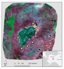
Very high resolution multispectral reflectance imagery, normalized difference vegetation index (NDVI), and digital surface and terrain models for a 0.5 km2 area surrounding Big Trail Lake (BTL) with soil collar locations for measuring carbon flux.

Remote Sensing and Invasive Species

Submitted by ORNL DAAC Staff on
Image Media
Image Media
Caption

Searching for the term remote sensing and words related to invasive species (invasive, nonnative, exotic, or nonindigenous) in Google Scholar reveals an increasing number of publications each year using these terms.

Body

A new Earthdata article describes how researchers are using remote sensing to map invasive species.