
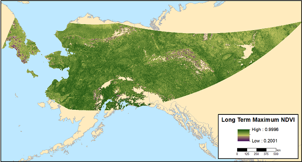
ABoVE: MODIS-derived Maximum NDVI, Northern Alaska and Yukon Territory for 2002-2017
A new dataset provides the maximum Normalized Difference Vegetation Index (NDVI) at 1-km resolution over northern Alaska, USA and the Yukon Territory, Canada, for each year from 2002-2017, as well as a 16 year maximum NDVI product. There are 17 data files in GeoTIFF (.tif) format: sixteen files with yearly maximum NDVI, and one file with the long-term maximum NDVI.
The Arctic-Boreal Vulnerability Experiment (ABoVE) is a NASA Terrestrial Ecology Program field campaign based in Alaska and western Canada between 2016 and 2021. Research for ABoVE links field-based, process-level studies with geospatial data products derived from airborne and satellite sensors, providing a foundation for improving the analysis and modeling capabilities needed to understand and predict ecosystem responses and societal implications.
See all data from the ABoVE campaign.
Data Citation: Verbyla, D. 2018. ABoVE: MODIS-derived Maximum NDVI, Northern Alaska and Yukon Territory for 2002-2017. ORNL DAAC, Oak Ridge, Tennessee, USA. https://doi.org/10.3334/ORNLDAAC/1614
Data Center: ORNL DAAC
Sponsor: EOSDIS
