Coastal Wetland Elevation and Carbon Flux Inventory with Uncertainty, USA, 2006-2011
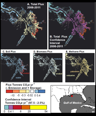
This Carbon Monitoring System (CMS) dataset provides maps of coastal wetland carbon and methane fluxes and coastal wetland surface elevation from 2006 to 2011 at 30 m resolution for coastal wetlands of the conterminous United States. Total coastal wetland carbon flux per year per pixel was calculated by combining maps of wetland type and change with soil, biomass, and methane flux data from a literature review. Uncertainty in carbon flux was estimated from 10,000 iterations of a Monte Carlo analysis. In addition to the uncertainty analysis, this dataset also provides a probabilistic map of the extent of tidal elevation, as well as the geospatial files used to create that surface, and a land cover and land cover change map of the coastal zone from 2006 to 2011 with accompanying estimated median soil, biomass, methane, and total CO2 equivalent annual fluxes, each with reported 95% confidence intervals, at 30 m resolution. Land cover was quantified using the Coastal Change Analysis Program (C-CAP), a Landsat-based land cover mapping product.
The CMS program is designed to make significant contributions in characterizing, quantifying, understanding, and predicting the evolution of global carbon sources and sinks through improved monitoring of carbon stocks and fluxes. See all ORNL DAAC data from the CMS.
Data Citation: Holmquist, J.R., L. Windham-Myers, B. Bernal, K.B. Byrd, S. Crooks, M.E. Gonneea, N. Herold, S.H. Knox, K. Kroeger, J. Mccombs, P.J. Megonigal, L. Meng, J.T. Morris, A.E. Sutton-grier, T. Troxler, and D. Weller. 2019. Coastal Wetland Elevation and Carbon Flux Inventory with Uncertainty, USA, 2006-2011. ORNL DAAC, Oak Ridge, Tennessee, USA. https://doi.org/10.3334/ORNLDAAC/1650
Data Center: ORNL DAAC
Sponsor: EOSDIS