
CO2 Observations, Modeled Emissions, and NAM-HYSPLIT Footprints, Boston MA, 2013-2014
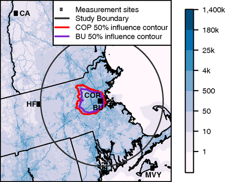
This dataset reports continuous atmospheric measurements of CO2 from two receptor sites and three boundary sites in and around Boston, Massachusetts, USA, that were combined with high-resolution CO2 emissions estimates and the Hybrid Single-Particle Lagrangian Integrated Trajectory (HYSPLIT) model to estimate regional CO2 emissions from September 2013 to December 2014.
The dataset contains three sets of data products:
(1) observed hourly mean CO2 observations for two urban receptor sites in Boston, MA (Boston University (BU) and Copley Square (COP))
(2) observed hourly mean CO2 and calculated vertical profiles (50 - 5000 m) for three boundary sites around Boston including Harvard Forest at Petersham, MA (HF), Canaan, NH (CA), and Martha's Vineyard, MA (MVY), and modeled mean boundary CO2 concentrations for particles released from BU and COP
(3) particle trajectory files including footprint values and CO2 enhancements above boundary CO2 concentrations from the HYSPLIT model
The North American Carbon Program (NACP) is a multidisciplinary research program designed to obtain scientific understanding of North America's carbon sources and sinks and changes in carbon stocks needed to meet societal concerns.
See all data from the NACP Project.
Data Citation: Sargent, M., S.C. Wofsy, and T. Nehrkorn. 2018. CO2 Observations, Modeled Emissions, and NAM-HYSPLIT Footprints, Boston MA, 2013-2014. ORNL DAAC, Oak Ridge, Tennessee, USA. https://doi.org/10.3334/ORNLDAAC/1586
Data Center: ORNL DAAC
Sponsor: EOSDIS
