
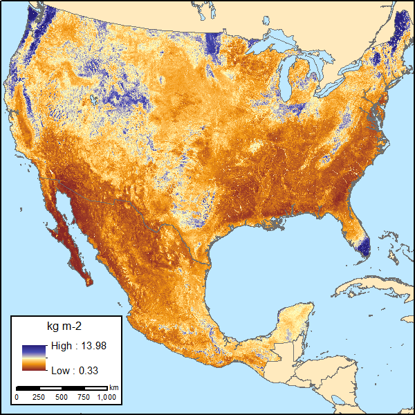
Soil Organic Carbon Estimates for 30-cm Depth, Mexico and Conterminous USA, 1991-2011
This dataset from the Carbon Monitoring System (CMS) provides two sets of gridded estimates of soil organic carbon (SOC) and associated uncertainties for 0-30 cm topsoil layer in kg SOC/m2 at 250-m resolution across Mexico and the conterminous USA (CONUS). The first set of gridded SOC estimates, for the period 1991-2010, were derived using multi-source SOC field data and multiple environmental variables representative of the soil forming environment coupled with a machine learning approach (i.e., simulated annealing) and regression tree ensemble modeling for optimized SOC prediction. Predictions of gridded SOC and uncertainty based on multiple bulk density (BD) pedotransfer functions (PFTs) are also included. The second set of gridded SOC estimates, for the period 2009-2011, were derived from two fully independent validation field datasets from across both countries. The same environmental variables and modeling approach used for the first set of estimates were applied to the second set to assess the models' sensitivity to multiple SOC data sources. The SOC field data for the first set of estimates are provided in this dataset and the other data sources, including the two independent validation field datasets, are referenced. Additionally, this dataset documentation provides author guidance on dataset usage and application.
NASA's CMS program is designed to make significant contributions in characterizing, quantifying, understanding, and predicting the evolution of global carbon sources and sinks through improved monitoring of carbon stocks and fluxes. The System uses NASA satellite observations and modeling/analysis capabilities to establish the accuracy, quantitative uncertainties, and utility of products for supporting national and international policy, regulatory, and management activities. CMS data products are designed to inform near-term policy development and planning. See all ORNL DAAC data from the CMS.
Data Citation: Guevara, M., C.E. Arroyo-cruz, N. Brunsell, C.O. Cruz-gaistardo, G.M. Domke, J. Equihua, J. Etchevers, D.J. Hayes, T. Hengl, A. Ibelles, K. Johnson, B. de Jong, Z. Libohova, R. Llamas, L. Nave, J.L. Ornelas, F. Paz, R. Ressl, A. Schwartz, S. Wills, and R. Vargas. 2020. Soil Organic Carbon Estimates for 30-cm Depth, Mexico and Conterminous USA, 1991-2011. ORNL DAAC, Oak Ridge, Tennessee, USA. https://doi.org/10.3334/ORNLDAAC/1737