Body
Two sets of estimated soil organic carbon and uncertainties are available at a 250 m resolution.

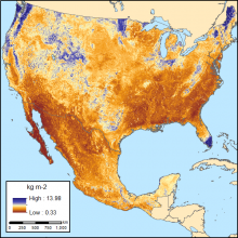
Soil organic carbon (SOC) for 0-30 cm topsoil layer in kg SOC/m2 at 250-m resolution across Mexico and the conterminous USA (CONUS) for the period 1991-2010.
Two sets of estimated soil organic carbon and uncertainties are available at a 250 m resolution.
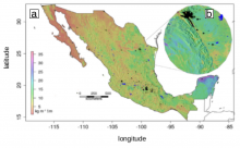
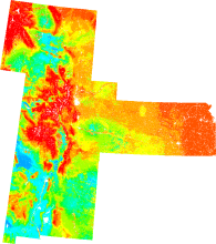
(A) Digital map of soil organic carbon (kg/m2) at 1 m depth and 90 m spatial resolution. The black and blue colored areas are urban areas and water bodies. (B) An area in northern Mexico illustrating the level of detail achieved by mapping across 90 m grids.
Estimates of soil organic carbon are now available from Mexico at a 90 meter resolution.

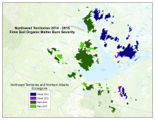
Study area included sites burned in 2014 and 2015 in the southeastern portion of the Northwest Territories and northern Alberta of Canada. The study area includes all 2014 and 2015 fires within a radius of approximately 300 km from Great Slave Lake.
Pre- and post-fire Landsat images were used to classify burn severity of soil organic matter across portions of arctic Canada.

Forced diffusion chambers were established at the seven sites along a south-to-north transect from near Fairbanks to Toolik Lake, Alaska.
Soil surface CO2 efflux in Alaska is available from the ABoVE field campaign.

Visualization of surface soil organic carbon fractions across the Great Plains region, USA, using nearest neighbor interpolation (from the ORNL DAAC Spatial Data Access Tool).
A new dataset provides gridded estimates of organic carbon in soil at 1 km resolution across four US states.
