
ABoVE: Characterization of Burned and Unburned Spruce Forest Sites, Tanana, AK, 2017
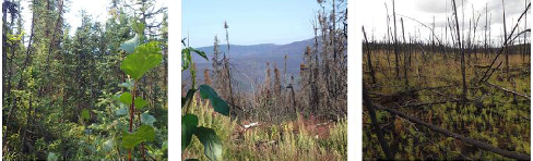
This dataset from the Arctic-Boreal Vulnerability Experiment (ABoVE) provides the results of field observations of soil characteristics and depth to permafrost, survey results for Composite Burn Index (CBI) determination, and Landsat-derived estimates of Relative Difference Normalized Burn Ratio (RdNBR) for 38 burned and unburned forest sites near Tanana, Alaska, in 2017. Forests in the study area, at the confluence of the Yukon and Tanana Rivers about 200 km west of Fairbanks, are predominately black spruce on wetter soils and white spruce on drier soils. The field surveys carried out in July 2017 were also used to verify locations of different burn severity classes (low, moderate, or high), as estimated in 2016 from Landsat images collected before and after the 2015 Tanana area wildfires.
ABoVE is a NASA Terrestrial Ecology Program field campaign that will take place in Alaska and western Canada between 2016 and 2021. See all data from ABoVE.
Data Citation: Potter, C.S., and C. Hugny. 2019. ABoVE: Characterization of Burned and Unburned Spruce Forest Sites, Tanana, AK, 2017. ORNL DAAC, Oak Ridge, Tennessee, USA. https://doi.org/10.3334/ORNLDAAC/1595
Data Center: ORNL DAAC
Sponsor: EOSDIS
