
Global Fire Atlas with Characteristics of Individual Fires, 2003-2016
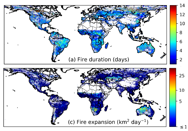
The Global Fire Atlas is a new global dataset that tracks the dynamics of individual fires to determine the timing and location of ignitions and fire size, duration, daily expansion, fire line length, speed, and direction of spread. These individual fire characteristics were derived from the Global Fire Atlas algorithm and estimated day of burn information at 500 m resolution from the Moderate Resolution Imaging Spectroradiometer (MODIS) Collection 6 MCD64A1 burned area product. The algorithm identified 13.3 million individual fires (over 0.21 km2) over the 2003-2016 study period. Global Fire Atlas data are provided as per-fire-year shapefiles, annual gridded layers, and monthly gridded layers.
Read more about the Global Fire Atlas in the related paper: https://doi.org/10.5194/essd-2018-89
NASA's Carbon Monitoring System (CMS) provided funding for this effort. CMS is designed to make significant contributions in characterizing, quantifying, understanding, and predicting the evolution of global carbon sources and sinks through improved monitoring of carbon stocks and fluxes.
See all ORNL DAAC datasets from the Carbon Monitoring System.
Data Citation: Andela, N., D.C. Morton, L. Giglio, and J.T. Randerson. 2019. Global Fire Atlas with Characteristics of Individual Fires, 2003-2016. ORNL DAAC, Oak Ridge, Tennessee, USA. https://doi.org/10.3334/ORNLDAAC/1642
Data Center: ORNL DAAC
Sponsor: EOSDIS
