
ABoVE: Atmospheric Profiles of CO, CO2 and CH4 Concentrations from Arctic-CAP, 2017
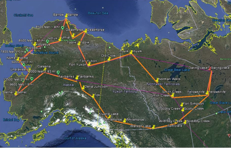
This dataset from the Arctic-Boreal Vulnerability Experiment (ABoVE) provides in situ airborne measurements collected over Alaska and Northwest Territories of Canada during the Arctic Carbon Aircraft Profile (Arctic-CAP) project. Arctic-CAP was designed to measure vertical profiles of atmospheric carbon monoxide, carbon dioxide, and methane concentrations to capture the spatial and temporal dynamics of the northern high latitude carbon cycle. During each of the six monthly campaigns, flights over the ABoVE domain included 25 vertical profiles, from the surface up to 6 km altitude, at locations selected to complement regular long-term vertical profiles, remote sensing data, and ground-based flux tower measurements.
ABoVE is a NASA Terrestrial Ecology Program field campaign that will take place in Alaska and western Canada between 2016 and 2021. Research for ABoVE will link field-based, process-level studies with geospatial data products derived from airborne and satellite sensors, providing a foundation for improving the analysis, and modeling capabilities needed to understand and predict ecosystem responses and societal implications. See all ORNL DAAC datasets from ABoVE.
Data Citation: Sweeney, C., and K. McKain. 2019. ABoVE: Atmospheric Profiles of CO, CO2 and CH4 Concentrations from Arctic-CAP, 2017. ORNL DAAC, Oak Ridge, Tennessee, USA. https://doi.org/10.3334/ORNLDAAC/1658
Data Center: ORNL DAAC
Sponsor: EOSDIS
