
ABoVE: River Ice Breakup and Freeze-up Stages, Yukon River Basin, Alaska, 1972-2016
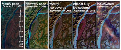
A new Arctic-Boreal Vulnerability Experiment (ABoVE) dataset provides estimates of river ice breakup and freeze-up stages along selected reaches of the Yukon and Tanana Rivers in the Yukon River Basin in interior Alaska from 1972-2016. Time series of Landsat satellite images were visually interpreted to identify the day of year and characteristics of the different stages of river ice seasonality. Not all stages were observed each year, and in some years, multiple dates of the same stage were observed. Independent datasets of local observations were used to validate the remote sensing classifications. The purpose of this study was to determine how river ice seasonality has changed over time and how the changes impact people who depend on rivers for travel and access to subsistence resources.
ABoVE is a NASA Terrestrial Ecology Program field campaign that will take place in Alaska and western Canada between 2016 and 2021. Research for ABoVE will link field-based, process-level studies with geospatial data products derived from airborne and satellite sensors, providing a foundation for improving the analysis, and modeling capabilities needed to understand and predict ecosystem responses and societal implications. See all ORNL DAAC data from ABoVE.
Data Citation: DBrown, D.R.N., T.J. Brinkman, and D. Verbyla. 2019. ABoVE: River Ice Breakup and Freeze-up Stages, Yukon River Basin, Alaska, 1972-2016. ORNL DAAC, Oak Ridge, Tennessee, USA. https://doi.org/10.3334/ORNLDAAC/1697
Data Center: ORNL DAAC
Sponsor: EOSDIS
