
ABoVE: Annual Thaw Slump Expansion on East Fork Chandalar River, Alaska, 2008-2017
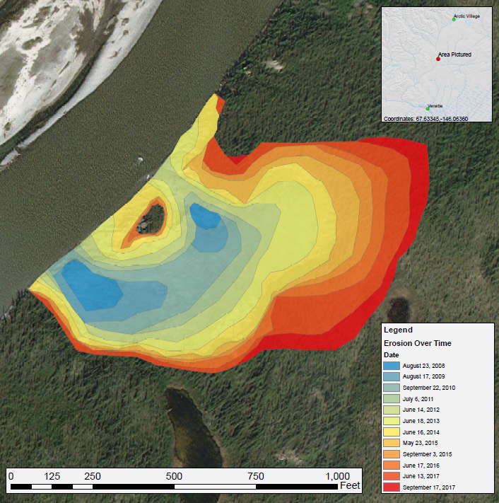
This Arctic-Boreal Vulnerability Experiment (ABoVE) dataset provides a time series of spatial data showing the expansion of a thaw slump on the East Fork Chandalar River near the community of Venetie, Alaska, from 2008 through 2017. The erosion of vegetated areas along the river was documented by manually digitizing imagery from ESRI base maps and Landsat 5 (TM), 7 (ETM+), and 8 (OLI), using the band combination of shortwave infrared 2, shortwave infrared 1, and red.
ABoVE is a NASA Terrestrial Ecology Program field campaign conducted in Alaska and western Canada between 2016 and 2021. Research for ABoVE links field-based, process-level studies with geospatial data products derived from airborne and satellite sensors, providing a foundation for improving the analysis, and modeling capabilities needed to understand and predict ecosystem responses to, and societal implications of, climate change in the Arctic and Boreal regions. See all ORNL DAAC data from ABoVE.
Data Citation: Anderson, V., D.R.N. Brown, and T.J. Brinkman. 2019. ABoVE: Annual Thaw Slump Expansion on East Fork Chandalar River, Alaska, 2008-2017. ORNL DAAC, Oak Ridge, Tennessee, USA. https://doi.org/10.3334/ORNLDAAC/1724
Data Center: ORNL DAAC
Sponsor: EOSDIS
