Body
ATL08 data is available to order via ORNL DAAC's MODIS/VIIRS Global Subsets tool.

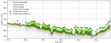
ATL08 data visualized along-track (100m step size), showing the estimated ground elevation, estimated canopy top height, and the individual photon return heights with their classifications. Image credit: Amy Neuenschwander, Center for Space Research, University of Texas.