
Tidal Wetland Soil Carbon Stocks for the Conterminous United States, 2006-2010
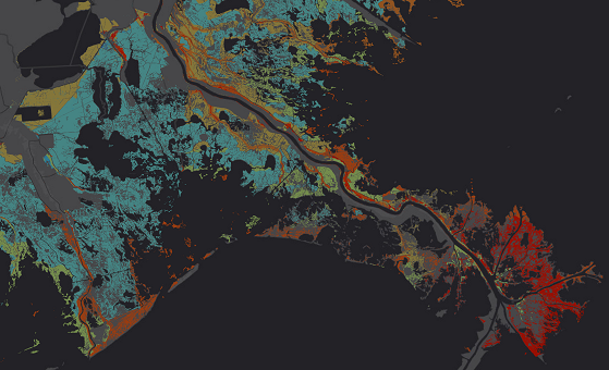
This new dataset from the Carbon Monitoring System (CMS) provides modeled estimates of soil carbon stocks for tidal wetland areas of the conterminous United States for the period 2006-2010. Wetland areas were determined using both 2006-2010 Coastal Change Analysis Program (C-CAP) raster maps and the National Wetlands Inventory (NWI) vector data. Multiple modeling strategies were used to determine the most accurate and precise method of mapping carbon stocks in tidal wetland areas. The modeling approaches included (1) applying a single average carbon stock value from the compiled soil core data, (2) applying models fit using the empirical data and applied spatially using soil, vegetation and salinity maps, (3) relying on independently generated soil carbon maps from The United States Department of Agriculture's Soil Survey Geographic Database (SSURGO), and the NWI that intersected with mapped tidal wetlands, and (4) using a version of SSURGO bias-corrected for bulk density.
The NASA Carbon Monitoring System is designed to make significant contributions in characterizing, quantifying, understanding, and predicting the evolution of global carbon sources and sinks through improved monitoring of carbon stocks and fluxes. See all ORNL DAAC datasets from the Carbon Monitoring System.
Related Publication: Holmquist, J., L. Windham -Myers, N. Bliss, S. Crooks, J.T. Morris, J.P. Megonigal, T. Troxler, D. Weller, J. Callaway, J. Drexler, M.C. Ferner, M.E. Gonneea, K.D. Kroeger, L. Schile-Beers, I. Woo, K. Buffington, J. Breithaupt, B.M. Boyd, L.N. Brown, N. Dix, L. Hice, B.P. Horton, G.M. MacDonald, R.P. Moyer, W. Reay, T. Shaw, E. Smith, J.M. Smoak, C. Sommerfield, K. Thorne, D.Velinsky, E. Watson, K.W. Grimes, and M. Woodrey. 2018. Accuracy and Precision of Tidal Wetland Soil Carbon Mapping in the Conterminous United States. Scientific Reports, Volume 8, Article number: 9478. https://doi/10.1038/s41598-018-26948-7
Data Citation: Holmquist, J.R., L. Windham-Myers, N. Bliss, S. Crooks, J.T. Morris, P.J. Megonigal, T. Troxler, D. Weller, J. Callaway, J. Drexler, M.C. Ferner, M.E. Gonneea, K. Kroeger, L. Schile-beers, I. Woo, K. Buffington, B.M. Boyd, J. Breithaupt, L.N. Brown, N. Dix, L. Hice, B.P. Horton, G.M. Macdonald, R.P. Moyer, W. Reay, T. Shaw, E. Smith, J.M. Smoak, C. Sommerfield, K. Thorne, D. Velinsky, E. Watson, K. Grimes, and M. Woodrey. 2019. Tidal Wetland Soil Carbon Stocks for the Conterminous United States, 2006-2010. ORNL DAAC, Oak Ridge, Tennessee, USA. https://doi.org/10.3334/ORNLDAAC/1612
Data Center: ORNL DAAC
Sponsor: EOSDIS

