Body
L2 orthocorrected reflectance from the Airborne Visible / Infrared Imaging Spectrometer-Next Generation (AVIRIS-NG) instrument.

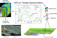
Overview of AVIRIS-NG applications, source: https://avirisng.jpl.`nasa.gov/aviris-ng.html .
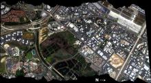
RGB composite image from AVIRIS-Classic flight f060510t01p00r06 on May 10 2006 over Irvine, California.
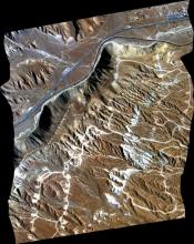
RGB composite image from AVIRIS-Classic flightline f170628t01p00r04 acquired on June 28 2017 northwest of Mojave, California.
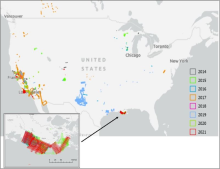
Location of AVIRIS-NG flight lines in conterminous US for 2014 - 2021. Inset shows detail of flight lines in coastal Louisiana associated with the Delta-X project.
Portion of quick look image for flight ang20200907t214229 on 07 September 2020 over the Russian River in Sonoma County south of Cloverdale, California (approximately 38.7392 lat, -122.9387 lon). Source: ancillary file ang20200907t214229_geo.jpg