Body
Monthly estimates of ocean surface pCO2 and air-sea flux of CO2 are available from NASA's Carbon Monitoring System.

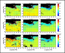
Monthly composite images of satellite-derived pCO2 for the northern Gulf of Mexico, corresponding to each of the cruises for which observational data were acquired. Black pixels in the images correspond to areas that were masked (e.g., land, clouds), and the dotted lines represent the 45 and 200 m isobaths.
Monthly estimates of ocean surface pCO2 and air-sea flux of CO2 are available from NASA's Carbon Monitoring System.
