Body
The second version of snowmelt timing maps for North America is available for the period 2001 through 2018.

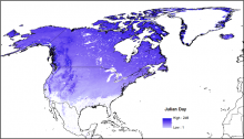
Mean snowmelt Day of Year (DOY) for the years 2001-2018 for North America. The DOY values for snowmelt timing were identified by observing the transition from snow-cover to no-snow for individual MODIS pixels throughout the annual melt period.
The second version of snowmelt timing maps for North America is available for the period 2001 through 2018.

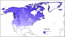
Mean snowmelt Day of Year (DOY) for the years 2001-2015 for North America. The DOY values for snowmelt timing were identified by observing the transition from snow-cover to no-snow for individual MODIS pixels throughout the annual melt period.
A new time-series analysis of snow cover has identified the day of snowmelt in each MODIS pixel across North America in each year from 2001 - 2015.
