Body
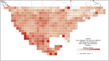
A new data set provides estimates of uncertainty in the daily temperature and precipitation values for North America provided by Daymet.


Daymet cross-validation tile-wide summary statistics for maximum temperature in 1980; 'daymae' = mean absolute error for single day predictions.
A new data set provides estimates of uncertainty in the daily temperature and precipitation values for North America provided by Daymet.
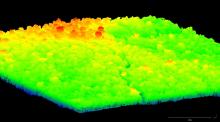
LiDAR point cloud of Fazenda Cauaxi, 2012. Points are colored by elevation above sea level. Orange and red trees extend above the surrounding canopy.
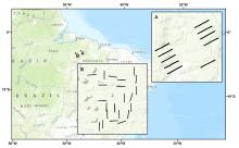
LiDAR surveys reveal the forest structure in five areas of Paragominas, Brazil.

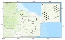
Forest inventory transect locations. Inset A is Fazenda Nova Neonita in Area PAR, and Inset B is Fazenda Cauaxi in Area CAU, in Paragominas, Para, Brazil.
An on-the-ground inventory of trees provides detailed biophysical data on tropical forests in Paragominas, Brazil.
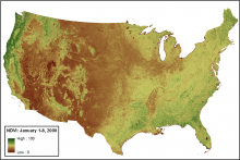
Smoothed and gap-filled NDVI for the conterminous US for the period January 1-8, 2000. NDVI is expressed as percent in this figure.
Vegetation "greenness" measured by MODIS NDVI for years 2000 - 2013 can be used a proxy for terrestrial productivity.

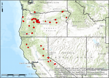
Locations of TERRA-PNW sampling areas in forests of the Pacific Northwest.
Comprehensive measurements of leaf, tree, and soil characteristics from forests in Oregon and Northern California are now available.

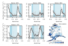
Methane flux measured at five flux tower sites on the North Slope of Alaska (from Zona et al, 2015)
A new CARVE data set shows the importance of cold-season emissions in the Arctic methane budget.
")
Dr. Yaxing Wei, Geospatial Information Scientist at the ORNL DAAC, has been recognized for his work.
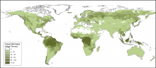
Global distribution of forest biomass in 1950 (Units: mega tonnes per deg. pixel).
New maps provide a high-resolution view of the global area covered by forest, forest growing stock, and biomass for the past 60 years.
.")
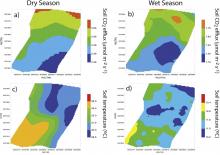
Spatial patterns of soil CO2 flux, soil temperature, soil water content, and leaf area index generated by ordinary kriging for the dry season (September) and the wet season (February).
Soil CO2 efflux and properties data for Baja California, Mexico are now archived at the ORNL DAAC.
 and the wet season (February).")
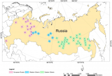
Distribution of the sites for which disturbance maps were generated.
Disturbance maps at 30-m resolution for selected sites across Northern Eurasia are now available in a new data set.
