Body
How can we better serve your research and data needs? The ORNL DAAC is seeking input from our user community.

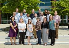
ORNL DAAC staff with an EOSDIS representative at the 2015 UWG Meeting at Oak Ridge National Laboratory.
How can we better serve your research and data needs? The ORNL DAAC is seeking input from our user community.

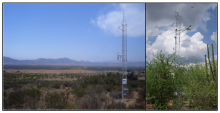
El Mogor tower (left; MX-Emg), Baja California, and Rayon tower (right; MX-Ray), Sonora, both in northwestern Mexico.
New data provide daily observations at two water-limited shrubland MexFlux sites in northern Mexico
, Baja California, and Rayon tower (right; MX-Ray), Sonora, both in northwestern Mexico.")
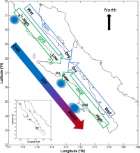
Transect locations are shown in relation to gradients of rain, SST, GPP (fPAR), and ocean upwelling zones, Baja California, Mexico.
Data derived from the MODIS sensor was used to measure the effects of the El Nino / Southern Oscillation on terrestrial productivity from 2000 - 2013.
, and ocean upwelling zones, Baja California, Mexico.")
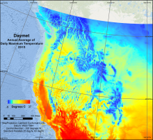
Average daily maximum temperature in 2015 from Daymet.
Daymet is a gridded data set of estimates of daily weather parameters for North America.

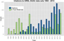
History of citation of data products archived at the ORNL DAAC.
Data citations provide credit to researchers for the data that they generate as well as enabling data reproducibility and re-use.

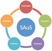
Semi-Automated ingest System (SAuS) design based on the essential 5-Ps for effective data stewardship.
A new paper summarizes the challenges of curating data and highlights a new workflow solution developed by the ORNL DAAC.
 design based on the essential 5-Ps for effective data stewardship.")
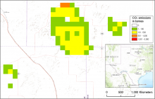
CO2 emissions in tonnes from a northern Texas fire in 2001 estimated by the Wildland Fire Emissions Information System (WFEIS v0.5).
The Wildland Fire Emissions Information System (WFEIS) provides annual emissions estimates for the conterminous US and Alaska from 2001-2013.


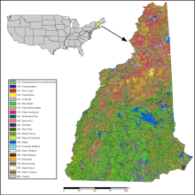
Land cover and land use classification for New Hampshire, 1996-2001, at 30-meter resolution. Legend includes all 23 class numbers and descriptions.
A new data set categorizes land cover and land use into 23 classes, based largely on the classification of 12 Landsat Thematic Mapper (TM) images.
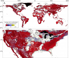
Map of average soil and sedimentary deposit thickness within each grid cell: (A) global, (B) subset of conterminous U.S.
A new data set in our soil collection provides high-resolution estimates of soil, regolith, and sediment deposit thickness for the globe.
 Global, (B) subset of conterminous U.S.")
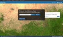
Earthdata Search Interface
Join us Thursday, 11 February 2016, from 2-3 pm EST to learn how NASA's Earthdata Search makes data search, discovery, visualization, and access faster and easier than ever.
