Body
A new data set records the air temperature and relative humidity around the Goddard Space Flight Center campus in suburban Maryland.

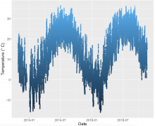
Temperature readings (degrees C) from Logger1 located in the Rain Garden near Building 32 on the Goddard Space Flight Center campus in Greenbelt, MD.
A new data set records the air temperature and relative humidity around the Goddard Space Flight Center campus in suburban Maryland.
 from Logger1 located in the Rain Garden near Building 32 on the Goddard Space Flight Center campus in Greenbelt, MD.")
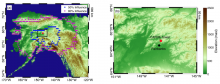
Location of the CARVE tower (red) and 50% and 80% surface influence contours for the average WRF-STILT influence functions (from Karion et al 2016).
A new data set investigates the atmospheric concentrations of CO2 and CH4 from 2012-2014 in boreal Alaska.
 and 50% and 80% surface influence contours for the average WRF-STILT influence functions (from Karion et al 2016).")
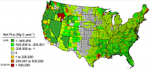
Average annual committed net carbon flux (Mg C/yr) from forests at the county scale (from Hagen et al.).
A new data set provides high-resolution maps of estimated carbon stocks of US forests for the years 2005-2010.
 at the combined country scale (from Hagen et al.).")
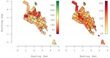
Predicted 2012 AGB (left) and associated 95% credible interval width (right) in Mg/ha for the PEF (from Babcock et al. 2016).
A new dataset provides estimates of aboveground biomass in Bradley, Maine.
 and associated 95% credible interval width (right) in Mg/ha for the PEF (from Babcock et al. 2016).")
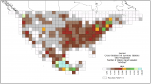
Daymet cross-validation showing the number of station-days evaluated, 'nstndays', per 2-degree by 2-degree Daymet tile for 1980 precipitation.
The Daymet data set has been updated to provide estimates of uncertainty in the daily temperature and precipitation values for North America.

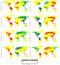
Vegetation productivity (blues/greens) follows the sun for a day. NEE for 3-hourly periods on July 1, 2007 for weighted ensemble mean product.
New global estimates of NEE between the land and atmosphere at 3-hourly time steps are available.
 follows the sun for a day. NEE for 3-hourly periods on July 1, 2007 for weighted ensemble mean product.")
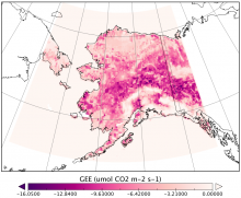
Gross ecosystem CO2 exchange (GEE) calculated using MODIS Enhanced Vegetation Index for 21:00 UTC, August 2, 2013. GEE typical of a mid-summer day.
A new CARVE data set provides 3-hourly estimates of gross ecosystem CO2 exchange (GEE) and respiration for Alaska from 2012 to 2014.
 calculated using MODIS Enhanced Vegetation Index for 21:00 UTC, August 2, 2013. GEE typical of a mid-summer day.")
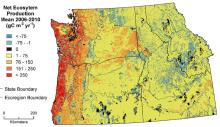
Mean net ecosystem production for 2006-2010 (Turner et al., 2016)
A new data set provides Biome-BGC modeled estimates of mean net ecosystem production (NEP), and mean carbon pool and flux estimates from 1986 to 2010.
")
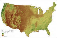
Smoothed and gap-filled NDVI for the conterminous US for the period January 1-8, 2000. NDVI is expressed as percent in this figure.
Year 2014 data has been added to the data set of smoothed and gap-filled NDVI derived from collection 5 MODIS for the US.

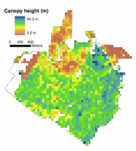
Lidar-derived mean vegetation canopy height in 1998 at 100-m (1-ha) resolution at La Selva Biological Station in Costa Rica.
Land-use, canopy height, and aboveground carbon estimates were derived from LiDAR data in March 1998 and March 2005.
 resolution at La Selva Biological Station in Costa Rica.")