Body
Eighteen years of annual gray wolf (Canis lupus) denning spatial information and timing across within the NASA ABoVE Core Domain recently published.

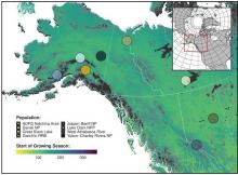
Spatial distribution of eight wolf study populations used in an assessment (from 2000-2017) of denning phenology in response to climate signals. The base map shows the day of the year representing the NDVI-derived start of the growing season in 2010.
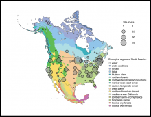
Spatial distribution of PhenoCam data across ecological regions of North America. Background map illustrates USA Environmental Protection Agency Level I Ecoregions. Data counts have been aggregated to a spatial resolution of 4i, and the size of each circle corresponds to the number of years of data.
A new version of the PhenoCam vegetation phenology data products is now available.
