Body
This new version of the Global Soil Respiration Database (SRDB) is a near-universal compendium of published soil respiration (Rs) data.

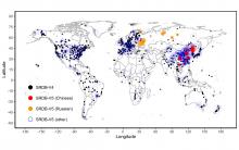
Locations of SRDB V5 observations combining pre-existing observations from V4 and new observations from Russian and Chinese literature, and literature from other languages (primarily English). Circle size represents sample size at each location.
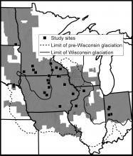
Study area in the Midwestern US with study site locations and extent of analysis. The study area was limited to the spatial extent of LiDAR topographic data (gray hillshade). Squares represent the 28 sites, a total of 210 km2, that were selected for having plowed, bare soil.
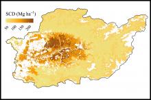
Map of predicted soil carbon density (SCD) over the study area in northern Borneo. Reproduced from Labriere et al. (2016).
ORNL DAAC data products were cited in over 300 peer-reviewed articles in 2018. Read about how these data are used in research.

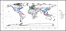
Locations of Soil Respiration Database Version 4 observations, colored by biome. Map produced by the companion SRDBv4.R script.
The Soil Respiration Database, a near-universal compendium of published soil respiration data, has been updated to version 4.0.
