Body
AKFED provides estimates of annual carbon emissions (kg carbon per square meter) from boreal fires in Alaska between 2001 and 2013.

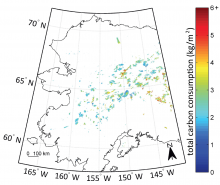
Total pyrogenic carbon consumption estimated from the AKFED between 2001 and 2012 (from Fig. 5 in Veraverbeke et al. 2015).
AKFED provides estimates of annual carbon emissions (kg carbon per square meter) from boreal fires in Alaska between 2001 and 2013.

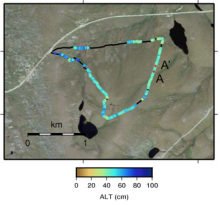
Active layer thickness derived from GPR data for the Basin Turnout route (from Fig. 5 in Chen et al., 2015)
New estimates of active layer thickness based on ground-penetrating radar available from the ABoVE project .

Open source Project for a Network Data Access Protocol (OPeNDAP)
On September 29th at 2:00 P.M. - 3:00 P.M. (EST), NASA's EarthData Webinar Series will present three different NASA EOSDIS instances of OPeNDAP and learn how to leverage these implementations for accessing NASA Earth science data.
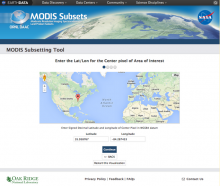
MODIS Subsetting Tool
The Global Subsetting Tool for MODIS Land Products is newly updated and now available.

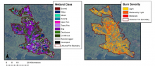
Utikuma site map showing peatland type for non-burned areas and modeled BSI for the Utikuma fire (Bourgeau-Chavez et al., 2015)
