Body
Ten recently published data sets provide historical environmental, soil, and vegetation data collected at study locations throughout Alaska.

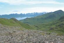
Vegetation on Unalaska Island, August 10th, 2007 (from Talbot et al., 2010).
Ten recently published data sets provide historical environmental, soil, and vegetation data collected at study locations throughout Alaska.
 on Unalaska Island, August 10th, 2007 (Talbot et al., 2010).")
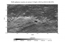
Infrared radiance of the land surface measured by the FLIR instrument onboard the CARVE flight on April 3, 2013.
A new data set provides measurements from the Forward Looking Infrared (FLIR) camera aboard the CARVE aircraft.

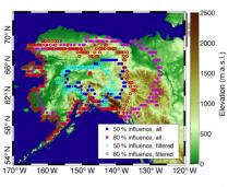
Surface contours for the average WRF-STILT influence functions show CO2 and CH4 measurements from the CARVE tower have a high sensitivity to the boreal forests and lowlands of interior Alaska (from Karion et al., 2016).
Two CARVE data sets provide modeled surface influence for particle receptors located at positions along CARVE flight paths and selected tower locations.
 for the average WRF-STILT influence functions (mid-afternoon averages 2012-2014) show CO2 and CH4 measurements from the CARVE tower have a high sensitivity to the boreal forests and lowlands of interior Alaska. Cyan and red circles are shown for the footprints after filtering (from Karion et al., 2016).")
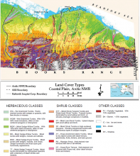
Land-cover map of the Coastal Plain, Arctic National Wildlife Refuge, Alaska, 1993. Sixteen land-cover types are noted, with a 17th notation for shadow (Jorgenson et al., 1994).
A landcover map for the northern coastal plain of the the Arctic National Wildlife Refuge (ANWR) has been released in support of NASA's ABoVE campaign.
.")
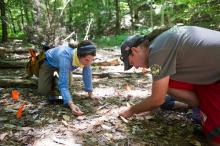
Dr. Istem Fer (L) and Dr. Michael Dietze (R) studying seedlings at the Bartlett Experimental Forest in Bartlett, NH. Photograph by Cydney Scott and courtesy of Dr. Michael Dietze.
Dr. Michael Dietze uses NASA data to improve ecological models through the integration of remotely-sensed data.
 and Dr. Michael Dietze (R) studying seedlings at the Bartlett Experimental Forest in Bartlett, NH. Photograph by Cydney Scott and courtesy of Dr. Michael Dietze.")
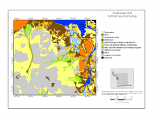
The Toolik Lake grid surficial geomorphology map (Walker and Maier, 2008).
A new data set provides standardized vegetation and environmental characteristics surrounding the Toolik Lake research site.
.")
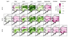
Optimized biogenic net CO2 flux for Alaska 2012-2014. The date of each measurement period is shown at the top of each map. From Commane et al. (2017)
CARVE campaign data show that Alaskan tundra may be shifting from a carbon sink to a carbon source.
")
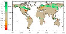
Change in the peatland area fraction between 13 kyBP and the present day. Negative values represent a larger peatland area fraction at 13 kyBP than at present (from Stocker et al., 2017).
A new data set provides reconstructions of past peatland carbon balance and land-use CO2 emission estimates.

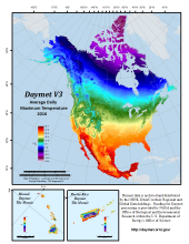
Daymet data is archived and distributed by the ORNL DAAC
Daymet takes in daily meteorological observations to produce high-resolution, gridded estimates of daily weather parameters across North America.


Attendees of the Data Management Best Practices Workshop on March 26, 2017
ORNL DAAC recently hosted a workshop on data management at the Joint NACP / Ameriflux meeting in Bethesda, MD.
