Body
The standard reference grid and official boundaries of the study domain are provided for the Arctic - Boreal Vulnerability Experiment (ABoVE).

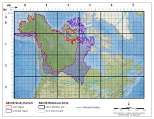
ABoVE spatial data products - the Study Domain with Core and Extended study regions displayed and the Standard Reference Grid showing the nested tiling scheme.
The standard reference grid and official boundaries of the study domain are provided for the Arctic - Boreal Vulnerability Experiment (ABoVE).

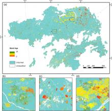
Stand age distribution map for the Siberian Larch forests in 2012. Insets show views of three subsets of the stand age map (from Chen et al., 2016).
High resolution maps of Siberian larch forests use fire history to infer stand age.
.")
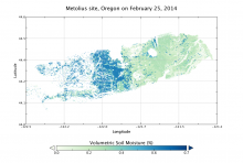
Modeled surface (0 - 10 cm) soil moisture at the Metolius site, Oregon, at midnight on Feb. 25, 2014.
A new dataset provides an hourly, gridded soil moisture product for nine AirMOSS sites.
 soil moisture at the Metolius site, Oregon, at midnight on Feb. 25, 2014.")
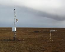
The eddy covariance site at Barrow, Alaska.
A new CARVE dataset provides 2011-2015 flux data from three eddy covariance tower sites in Alaska.

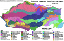
Ecological landscape sections from Landscape Level Ecological Mapping of Northern Alaska (2014 Update). From Jorgenson and Grunblatt, 2013.
Ecosystem types, vegetation, and land cover maps are provided in a new data set from NASA's ABoVE campaign.
. From Jorgenson and Grunblatt, 2013.")
Land surface fractional open water for the extended ABoVE domain for Julian days 171-180 of 2002 depicted with a black to white gradient.
Land surface fractional open water cover maps are provided for the pan-Arctic and the ABoVE study domains.

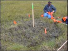
Frost-boil vegetation plot at Franklin Bluffs in northern Alaska
A new dataset provides baseline information on vegetation and soils at 117 study plots on Arctic frost-boils.

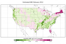
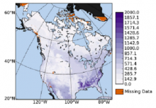
Estimated continental-scale Net Ecosystem Exchange (NEE) of CO2 in February 2012.
AirMOSS data provide daily estimates of Net Ecosystem Exchange (NEE) at seven Fluxnet sites, and hourly and monthly estimates for the whole North American region.
 of CO2 in February 2012.")
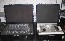
Flask sampling system for aircraft measurements. Left: Programmable Flash Package (PFP) containing 12 flasks. Right: Programmable Compressor Package (PCP) containing pumps for pressurizing the flasks. (Image courtesy: http://www.esrl.noaa.gov/gmd/ccgg/aircraft/sampling.html)
The CARVE campaign analyzed whole-air samples from aircraft and a 32m tower above Alaska.
 containing 12 flasks. Right: Programmable Compressor Package (PCP) containing pumps for pressurizing the flasks. (Image courtesy: http://www.esrl.noaa.gov/gmd/ccgg/aircraft/sampling.html)")
VPRM annual integrated respiration for 2002 provided in g C/m2/yr. Black areas are outside the study domain (Hilton et al., 2014).
A new data set provides parameters for the Vegetation Photosynthesis Respiration Model (VPRM) for 65 flux sites.
.")