Body
Airborne Microwave Observatory of Subcanopy and Subsurface (AirMOSS) radar data from Alaska are used to derive estimates of active layer thickness. Data from flights in 2014 and 2015 are now available.

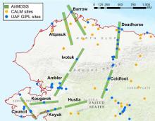
AirMOSS radar swaths flown in 2014 and 2015 in Alaska. In situ soil moisture and temperature profile measurements were obtained at the CALM (Circumpolar Active Layer Monitoring) and the UAF GIPL (Geophysical Institute Permafrost Laboratory, University of Alaska Fairbanks) sites and used to validate AirMOSS data products.
Airborne Microwave Observatory of Subcanopy and Subsurface (AirMOSS) radar data from Alaska are used to derive estimates of active layer thickness. Data from flights in 2014 and 2015 are now available.

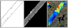
Example of AirSWOT radar products in ABoVE Projection at 3.6 m resolution, for a flight over the ABoVE C grid Ch065v034. Left: Shape for backscatter image. Middle: Backscatter magnitude shows bright reflection in the near range and no returns, yielding regions of no data, in the far range. Right: Derived elevation product.
The ABoVE project has released data from AirSWOT flights in Summer 2017 collected over Alaska and Canada.
