Body
An updated dataset characterizes vegetation canopy structure in the Great Smoky Mountains National Park.

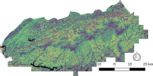
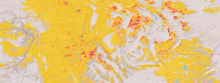
This overview map shows thirty unique vegetation canopy structure classes identified within the Great Smoky Mountain National Park in Tennessee and North Carolina, USA.
An updated dataset characterizes vegetation canopy structure in the Great Smoky Mountains National Park.

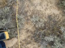
Typical plot photo for ground cover estimates and location of LAI measurements. A rangepole with GPS and a camera boom was positioned at 2-meter intervals along plot transects. This photo is from the Hollister, Sagebrush01 plot, and the Sagebrush01_5_4 sampling point.
New field data describes vegetation in southern Idaho in order to validate remotely-sensed data in the region.

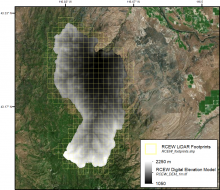
Digital elevation model and LiDAR tile boundaries for the area encompassing the Reynolds Creek Experimental Watershed in southwestern Idaho.
LiDAR data collected over southern Idaho was used to derive a high resolution digital elevation model and map of vegetation height across a strong regional climate gradient.

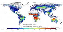
Annual burned area (as percentage of the area of the grid cell), averaged over 1997-2014
A new version of the GFED data provides global fire and emissions data from 1997 to 2016.

Tree mortality (in units of Mg aboveground carbon per square kilometer) on forested land in portions of Idaho and Montana in 2009.
A new dataset quantifies the biomass of trees killed by fires and bark beetles across the western US.

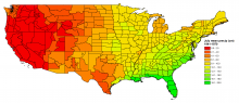
Data set C14: Monthly average precipitation for July by state climatic division 1941-1970.
The ORNL DAAC has revised a dataset that includes a variety of environmental, climate, and socioeconomic variables at the county level for the period 1941 to 1981.

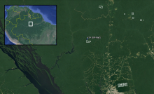
Footprints for surveyed areas in Amazonas, Brazil are included in amazonas_lidar_footprints.shp. The K34 eddy flux tower (AmeriFlux BR-Ma2) is within the surveyed area at the Cuieiras Biological Reserve.
A new dataset provides LiDAR point clouds and digital terrain models (DTM) from surveys near the Cuieiras Biological Reserve, Adolpho Ducke Forest Reserve, and Rio Preto da Eva municipality near Manaus, Amazonas, Brazil.

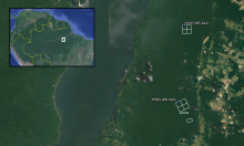
Footprints from each of the surveyed areas within Tapajos National Forest in Para, Brazil are included in TAP_A_footprints.shp. The Km67 and Km83 eddy flux towers (AmeriFlux Sites BR-Sa1 and BR-Sa3) are within the surveyed areas.
A new dataset provides LiDAR point clouds and digital terrain models (DTM) from surveys over the Tapajos National Forest, Brazil during 2008.

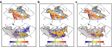
Maps of derived metrics aggregated to 1 degree for (a) crown scorch, (b) vegetation combustion, and (c) total relative tree mortality (from Rogers et al., 2015, Supplementary Figure 4).
A new data set characterizes the immediate and longer-term ecosystem changes from fires in the boreal forests of Northern Eurasia and North America.

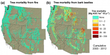
Cumulative tree mortality due to (a) fires and (b) bark beetles from 2003-2012 on forestland in the western United States (from Berner et al., 2017, in review).
Wildfire and bark beetles caused tree mortality, and decreased carbon storage, in areas of the western USA from 2003-2012.
