Body
A long-term record of annual forest fire burned area and daily hotspots are provided in a new ABoVE dataset.

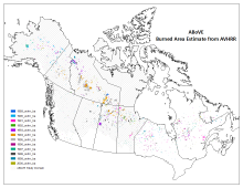
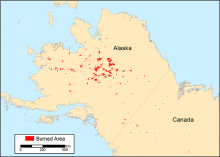
The ABoVE study domain showing cumulative annual burned areas derived from AVHRR for 1989 - 2000.
A long-term record of annual forest fire burned area and daily hotspots are provided in a new ABoVE dataset.

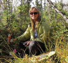
Dr. Laura Bourgeau-Chavez using a handheld water content reflectometer to measure soil moisture at a field site in Delta Junction, Alaska. Image courtesy of Dr. Bourgeau-Chavez.
Dr. Laura Bourgeau-Chavez uses NASA Earthdata for studying wetlands and wildfire.

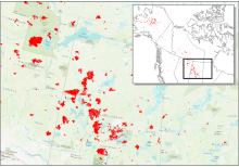
Date of Burning (DoB) was estimated for areas within each fire scar across Alaska and Canada. In this figure, red areas are fire scar locations across central Canada in 2015.
New data from NASA's ABoVE project provide maps of the date of burning within fire scars across Alaska and Canada from 2001-2015.

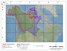
The ABoVE Study Domain with Core and Extended study regions and the Standard Reference Grid showing the nested 240 and 30 meter tiling scheme.
An updated version of the standard reference grid for NASA's ABoVE campaign has been released.

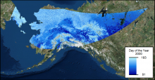
Date of last spring snow cover for portions of Alaska and the Yukon Territory in 2000. Data spatial extent is based on the MODIS sinusoidal projection.
Data from NASA's ABoVE campaign tracks the last day of spring snow cover for parts of Alaska and the Yukon Territory annually from 2000 through 2016.

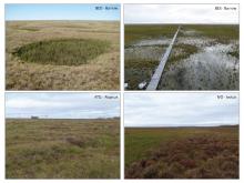
Land cover types and topography at the flux tower field sites at Barrow, Atqasuk, and Ivotuk, Alaska
Historical data from the ABoVE project characterize vegetation within five flux tower footprints in Alaska.

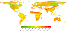
Global map of MODIS-derived clumping index in 2006 (from He et al. 2012). Clumping index values range from 0 to 1 (maximum clumping to minimum clumping) representing the degree of foliage grouping within distinct canopy structures, such as tree crowns, shrubs, and row crops, relative to a random distribution.
A new dataset provides a high-resolution global clumping index derived from MODIS.

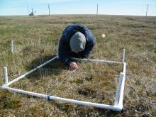
Surveying tundra vegetation at the Barrow, Alaska research site.

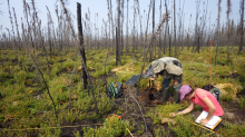
Researchers examine a burned site near Kakisa in Canada's Northwest Territories as part of NASA's ABoVE field campaign.

Cumulative end-of-season burned area for the year 2015 in a subset of Alaska and Western Canada.
Researchers with ABoVE have mapped the 14 year history of burned areas above 60 degrees N.
