Body
Spatial data on disturbance agents of fire, insects, and logging in the ABoVE core domain at an annual time step from 1987-2012 and 30 m resolution.

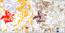
Casual agents of disturbance for the year 2006 in the ABoVE domain for tile BH19V15 (A) with the Tasseled Cap change (dTC) image in the same year for the same region (B). In the dTC image, Band_1 is change in brightness; Band_2 is change in greenness; Band_3 is change in wetness. The pixel resolution is 30 meters.
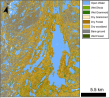
Figure 1. A preliminary wetland classification for Canadian Shield lakes north of Yellowknife, NWT, Canada. Missing data in some lakes appear as white spots
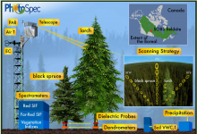
Diagram of the field set-up. This dataset provides the products collected using PhotoSpec mounted at the top of the tower. Measurements collected from other instrumentation shown are not provided in this dataset. Source: Pierrat et al., 2021
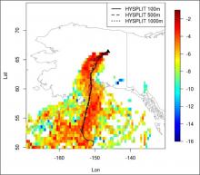
Subset of STILT footprint domain showing contributions overlain by HYSPLIT trajectories from receptors located at 100 (solid), 500 (dashed), and 1,000 m (dotted) at 19:35 UTC 2012-08-20.
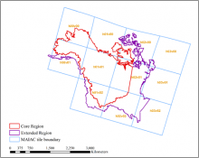
MAIAC tiles (blue squares with yellow labels) and ABoVE core (red) and extended (purple) domain boundaries covering Alaska and western Canada. Source: adapted from Yu et al. 2021
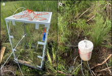
Chambers used to measure diffusive CH4 fluxes. a) Large chamber resting on the pre-installed aluminum collar, sealed on edges with pipe insulation. b) Five-gallon (18.9-liter) bucket with an open bottom and air-tight screw lid to measure hotspot flux locations.
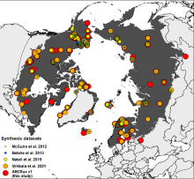
The flux site distribution in syntheses focused on compiling fluxes from high latitudes (McGuire et al. 2012, Belshe et al. 2013, Natali et al. 2019, Virkkala et al. 2021 and this study (ABCflux)). The Arctic-Boreal Zone is highlighted in dark grey; countries are shown in the background. Based on the unique latitude-longitude coordinate combinations in the tundra, there were 136 tundra sites in ABCflux, 104 tundra sites in Virkkala et al. 2021, 68 tundra sites in Natali et al., 2019, 34 tundra sites in Belshe et al. 2013, and 66 tundra sites in McGuire et al., 2012. Observations that were included in previous studies but not in ABCflux represent fluxes aggregated over seasonal, not monthly periods.
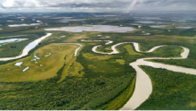
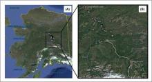
Aerial view of the Yukon Delta landscape near the village of Emmonak, August 2017
Map indicating the location of the study sites.
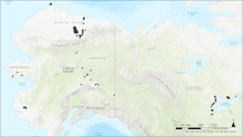
Locations of boreal forest stands in interior Alaska where forest structure and composition were measured and compared to remotely-sensed NDVI trends (Fiore et al., 2020).