Body
The ORNL DAAC has discontinued FTP browsing and now offers HTTPS browsing for our data archive.

HTTPS browsing the ORNL DAAC data archive.

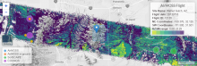
Screenshot of the map portion of the Soil Moisture Visualizer
The ORNL DAAC'S Soil Moisture Visualizer offers numerous soil moisture data sets via a single graphical interface.


Photo of Dr. Nancy Glenn by Allison Corona, Boise State University.
Dr. Nancy Glenn uses NASA remote sensing data to study vegetation, soils, and landscape change in drylands of the western US.

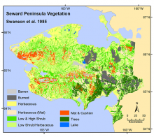
Vegetation map of the Seward Peninsula (Range Map, Swanson et al., 1985).
Digital landcover and vegetation maps for the Seward Peninsula are provided as part of the ABoVE project.
.")
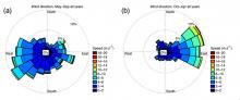
Wind roses averaged over (a) May-September and (b) October-April for all 3 years during mid-afternoon hours at 32 m above ground level on the CARVE tower (from Karion et al., 2016).
A new CARVE dataset provides measurements of CO2, CH4, and other gases from a fixed tower outside Fairbanks, Alaska.
 May-September and (b) October-April for all 3 years during mid-afternoon hours at 32 m above ground level on the CARVE tower (from Karion et al., 2016).")
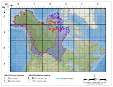
ABoVE spatial data products - the Study Domain with Core and Extended study regions displayed and the Standard Reference Grid showing the nested tiling scheme.
The standard reference grid and official boundaries of the study domain are provided for the Arctic - Boreal Vulnerability Experiment (ABoVE).

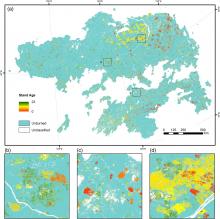
Stand age distribution map for the Siberian Larch forests in 2012. Insets show views of three subsets of the stand age map (from Chen et al., 2016).
High resolution maps of Siberian larch forests use fire history to infer stand age.
.")
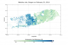
Modeled surface (0 - 10 cm) soil moisture at the Metolius site, Oregon, at midnight on Feb. 25, 2014.
A new dataset provides an hourly, gridded soil moisture product for nine AirMOSS sites.
 soil moisture at the Metolius site, Oregon, at midnight on Feb. 25, 2014.")
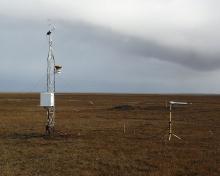
The eddy covariance site at Barrow, Alaska.
A new CARVE dataset provides 2011-2015 flux data from three eddy covariance tower sites in Alaska.

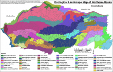
Ecological landscape sections from Landscape Level Ecological Mapping of Northern Alaska (2014 Update). From Jorgenson and Grunblatt, 2013.
Ecosystem types, vegetation, and land cover maps are provided in a new data set from NASA's ABoVE campaign.
. From Jorgenson and Grunblatt, 2013.")