Body
A new ABoVE dataset provides a 28-year time series of peak greenness data derived from Landsat 5 TM imagery over the Boreal forest region of Canada.

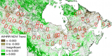
Sites used in this study are shown with AVHRR NDVI trends from Beck and Goetz (2011). Figure from Sulla-Menashe et al. (2018)
A new ABoVE dataset provides a 28-year time series of peak greenness data derived from Landsat 5 TM imagery over the Boreal forest region of Canada.

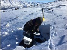
Measurement of snowpack characteristics and track sink depths at a Dall sheep (Ovis dalli dalli) track site in March 2017 on Jaeger Mesa, Wrangell St. Elias National Park and Preserve, Alaska (from Sivy et al., 2018).
Research from NASA's ABoVE campaign examines how snow characteristics may affect populations of Dall sheep.
 track site in March 2017")
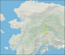
Locations of thaw depth measurement sites. Three of the locations are paired unburned-burned sites.
New data from ABoVE provide thaw depth at burned and unburned sites across Alaska.

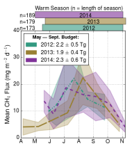
Monthly mean CH4 flux estimates for Alaska. Values are centered on the mean measurement date for a given month and the shaded regions are the standard error of the mean (figure from Hartery et al. 2018).
A new dataset from NASA's Carbon in Arctic Reservoirs Vulnerability Experiment (CARVE) provides gridded methane flux estimates from 2012-2014.

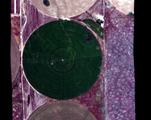
A portion of the quicklook image from flight line ang20150611t202652 over Reynolds Creek Experimental Watershed, Idaho on June 6, 2015. Center-pivot irrigation of agricultural land (1/2 mile in diameter) is visible in this image. Flight altitude was approximately 3000 m with clear weather.
A new dataset provides surface reflectance measured in 2014 & 2015 at long-term research sites in Idaho and California, USA.
 is visible in this image.")
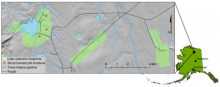
Location of Toolik Lake study area in northern Alaska. Detail view shows three LiDAR collection footprints in pale green. Red crosses indicate locations of shrub harvest areas within the Toolik LiDAR footprint (figure from Greaves et al., 2016).
LiDAR and orthophotography were used to estimate aboveground shrub biomass near Toolik Lake, AK.

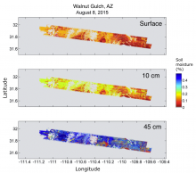
Soil moisture estimates at the Walnut Gulch site, Arizona, reveal a dry soil surface, but considerably more moisture at 45 cm depth.
A new version of the AirMOSS root zone soil moisture data product is now available.

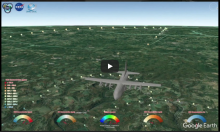
This Fly Along video shows the ACT-America aircraft in flight over Pennsylvania in July 2016. The circles behind the aircraft represent carbon dioxide measurements taken continuously during the flight.
Fly along with the Atmospheric Carbon and Transport – America (ACT-America) as they sample the air above the Eastern United States on July 26, 2016.

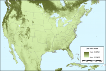
Average leaf area index during January (2003-2010). This figure was created from the data file leaf_stem_area_index_monthly_climatology_2003-2010.nc4.
Vegetation and albedo parameters from MODIS Collection 5 were reprocessed for use in regional agroecosystem-climate models.

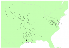
Locations of ACT-America flask air samples from flights in July and August 2016.
A new dataset from ACT-America provides data from airborne flasks collected during the Summer 2016 campaign.
