Body
The ABoVE campaign provides historical environmental and vegetation data at Alaskan research sites.

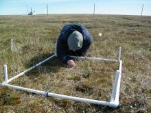
Surveying tundra vegetation at the Barrow, Alaska research site.

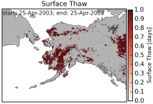
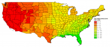
Map of thawed land surfaces in Alaska as measured by the AMSR-E satellite radiometer on April 25, 2003.
New data from NASA's CARVE provides daily maps of the thaw state of Alaska's land surface from 2003 to 2014.

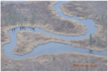
Photo taken on the 8 October 2015 CARVE flight above the Innoko National Wildlife Refuge in Alaska.
Photos and videos taken during CARVE flights, as well as daily flight reports, are now available online.


The NASA EOSDIS 2017 American Customer Satisfaction Index (ACSI) Survey collects valuable feedback from our users. Please Participate.

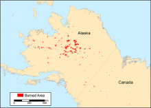
Cumulative end-of-season burned area for the year 2015 in a subset of Alaska and Western Canada.
Researchers with ABoVE have mapped the 14 year history of burned areas above 60 degrees N.


Presenters from the Ecology from Space workshop on August 10, 2017. From left: Michele Thornton (ORNL DAAC), Pinki Mondal (SEDAC), Alison Boyer (ORNL DAAC), and Jennifer Brennan (EOSDIS). Cole Krehbiel (LP DAAC) is not pictured.
On August 10, 2017, ORNL DAAC staff organized an informational workshop at the annual meeting of the Ecological Society of America.

Data set C14: Monthly average precipitation for July by state climatic division 1941-1970.
The ORNL DAAC has revised a dataset that includes a variety of environmental, climate, and socioeconomic variables at the county level for the period 1941 to 1981.

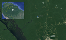
Footprints for surveyed areas in Amazonas, Brazil are included in amazonas_lidar_footprints.shp. The K34 eddy flux tower (AmeriFlux BR-Ma2) is within the surveyed area at the Cuieiras Biological Reserve.
A new dataset provides LiDAR point clouds and digital terrain models (DTM) from surveys near the Cuieiras Biological Reserve, Adolpho Ducke Forest Reserve, and Rio Preto da Eva municipality near Manaus, Amazonas, Brazil.

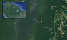
Footprints from each of the surveyed areas within Tapajos National Forest in Para, Brazil are included in TAP_A_footprints.shp. The Km67 and Km83 eddy flux towers (AmeriFlux Sites BR-Sa1 and BR-Sa3) are within the surveyed areas.
A new dataset provides LiDAR point clouds and digital terrain models (DTM) from surveys over the Tapajos National Forest, Brazil during 2008.

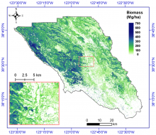
Estimated aboveground biomass (Mg/ha) for Sonoma County at 30-m spatial resolution using the random forest method. Zoom-in figure is a subset near Santa Rosa, the largest city in California's North Coast.
High-resolution estimates of aboveground biomass, canopy height, and percent tree cover are available for Sonoma County, California, USA.
