Body
Vegetation community characteristics, soil moisture, and biophysical data collected in 2017 from 11 study sites in the ABoVE Study area.

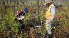
Researchers collecting data on vegetation and biophysical characteristics at a study site in Northwest Territories of Canada that was burned by wildfires in 2014-2015.
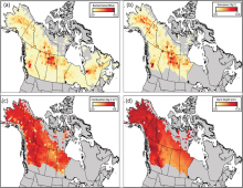
Total burned area (a), total carbon emissions (b), mean combustion (c), and mean burn depth (d) between 2001-2019 aggregated to a 70 km grid. Note that burned area (a) covers all of Alaska and Canada whereas all other metrics cover the ABoVE extended domain.
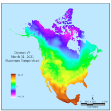
Maximum Temperature from Daymet Version 4 Monthly Latency: Daily Surface Weather Data on March 31, 2021 was produced in April of 2021.
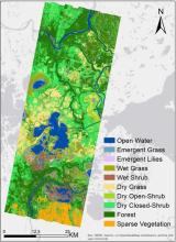
The wetland vegetation community classification for the Peace-Athabasca Delta, Alberta, Canada created from AVIRIS-NG derived features.
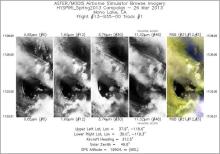
Single band images and an RGB composite image from flight track 1 acquired on 26 March 2013 over Mono Lake, California, U.S. Source: /MASTERL1B_1393500_01_20130326_1728_1733_V01.jpg from dataset MASTER: HyspIRI Airborne Campaign, California, Early Spring 2013.
Banner image announcing the ARSET Evaluating Ecosystem Services with Remote Sensing
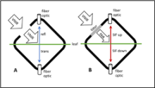
Schematic of FluoWat leaf clip operation for measuring leaf reflectance, transmittance, and upward and downward fluorescence (SIF). The leaf is placed in the clip and illuminated through the open port (A). Reflected and transmitted radiance are measured by attaching a fiber optic cable from the spectrometer to the top or bottom of the clip. To measure fluorescence spectra a low pass filter is placed across the illumination port (B). Two filters are applied in sequence, they block incident wavelengths above 650 nm and 700 nm, therefore any radiance measured in the longer wavelengths can come only from fluorescence.
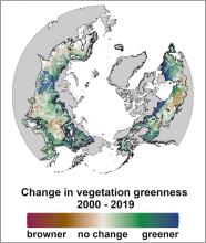
Change in greenness of boreal forest across the northern hemisphere between 2000 to 2019, estimated from an ensemble of vegetation indices derived from Landsat imagery.
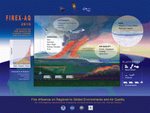
Themes of the FIREX-AQ program. Source: https://csl.noaa.gov/projects/firex-aq/about/
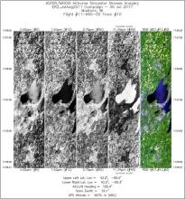
Single band images and an RGB composite image from flight track 10 acquired on 30 July 2011 over Madison, Wisconsin, U.S. Source: MASTERL1B_1166500_01_20110730_1520_1528_V01.jpg