Body
Selected aerosol and gas-phase observations made on all four deployments of NASA Atmospheric Tomography Mission (ATom).

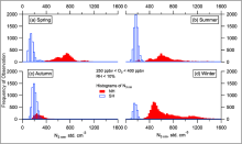
Histograms of the total number of aerosols between 3 and 4500 nm in the LMS (ozone 250-400 ppbv, altitude > 8 km) for the SH and NH) for all ATom deployments (a-d), by season. Modified from fig. 2 of Williamson et al. (2021).
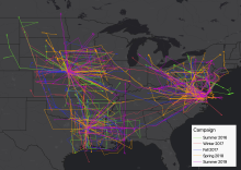
Flight paths for five airborne campaigns of ACT-America that provided receptor locations and CO2 measurements for these FLEXPART simulations. Flights were concentrated on three study areas: the northeast, south-central, and mid-west regions of the United States.
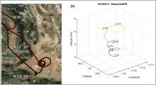
(a) Flight track for 10 February 2016 flight over Edwards AFB, California. (b) Time-tagged location and altitude plot for the spiral-down maneuver over Edwards AFB for the same flight (Abshire et al., 2018).
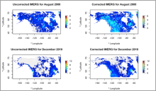
Two examples of uncorrected and corrected months Canada-Alaska domain. The correction is applied to pixels > 500 m, so the correction is seen primarily in mountainous areas. Figure from Lober et al. (in review).
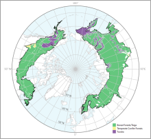
Tree canopy cover over global boreal forests in 2020.
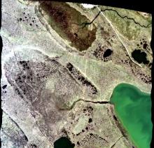
A portion of the quicklook image from flight line ang20170714t212855 over Barrow, Alaska on July 14, 2017. Two sites (AB_B10_L001_FL175_PipelineLake and AB_B10_L003_FL175_PipelineLake) of interest to the ABoVE project are visible. Flight altitude was approximately 5,400 m with very thin cirrus cloud cover.
ARSET - Disaster Assessment Using Synthetic Aperture Radar webinar banner.
The Claes Fornell International (CFI) Group has concluded feedback solicitation on behalf of NASA for EOSDIS DAACs to determine customer satisfaction in 2022.
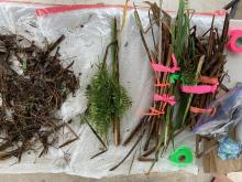
Aboveground vegetation sorted by species into biomass and necromass components.