Body
Ranson et al. used MODIS data to map tree cover at the Earth's longest vegetation transition zone.

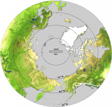
MODIS true-color, cloud-free composite of the northern hemisphere in 2001. The circumpolar taiga-tundra ecotone benchmarked in this study is about 13,400 km long (Image source: NASA).
Ranson et al. used MODIS data to map tree cover at the Earth's longest vegetation transition zone.

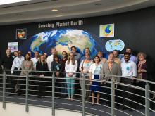
May 2016 UWG Meeting at Goddard Space Flight Center
The ORNL DAAC User Working Group met at Goddard Space Flight Center on May 23rd - 25th, 2016.

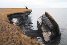
Large sections of exposed permafrost are visible after a portion of Alaska's coastal tundra collapsed. (Photo by USGS Alaska Science Center.)
The warming of permafrost soils is expected to increase methane and carbon dioxide emissions.
")
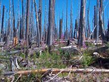
In this photograph, taken eleven years after the Charlton Fire in Oregon's Willamette National Forest, a majority of snags still stand while gradually new vegetation is growing. (Courtesy M. Spencer)
Decades after a fire, high-elevation forests still shape the climate.
")
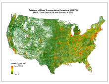
Tons of CO2 emitted from vehicles in 2012 from the Database of Road Transportation Emissions.


Nine Steps to Sharing Your Environmental Data Set
Careful data management is key when you plan to share your data with others. Here are 9 simple steps researchers can to follow make your data set ready to share.

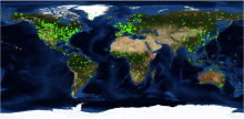
Locations of the 1,100+ field sites with available 7 x 7-km MODIS land product subsets.
Subset and visualize MODIS collection 5 land products using the MODIS fixed sites and Web service tools.

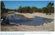
USGS scientists track the timing of the long-awaited return of the Colorado River to its parched delta in Mexico on March 24, 2014.
Do we have enough water to meet our needs, now and in the future? Daymet, a meteorological data product at the ORNL DAAC, may help find the answer.


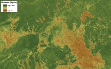
MODIS satellite data inform study of human land use patterns and changes in ecological communities in tropical forests around the world.
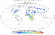
A comprehensive, harmonized data set describing the annual land use patterns of the globe from the year 1500 to the present, and projections to the year 2100, is now available from the ORNL DAAC.
