Body
NASA's ABoVE provides standardized data on potential climate drivers for productivity of Arctic tundra vegetation.

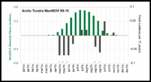
Arctic biweekly NDVI (green bars) and trend (grey bars) for full tundra for 1999-2015. Biweekly trends statistically significant at the 95% level or greater are marked with an asterisk on the x-axis. From Figure 9 (c) Bhatt et al. (2017) (see dataset documentation).
NASA's ABoVE provides standardized data on potential climate drivers for productivity of Arctic tundra vegetation.

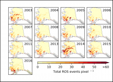
Annual time series of days with rain-on-snow summed for each 6-km pixel in Alaska.
Researchers with NASA's ABoVE campaign mapped rain-on-snow events across Alaska from 2003 to 2016.

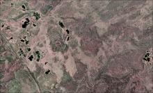
Orthomosaic imagery taken from a Beechcraft Super King Air B200 aircraft traveling north of the Mackenzie River in the Dehcho Region of Canada.
NASA's 2017 ABoVE airborne campaign provides high-resolution, georeferenced, three-band orthomosaics of digital imagery to validate maps of Arctic surface water extent.

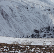
A herd of Dall sheep ewes and lambs in Wrangell-St. Elias National Park & Preserve, Alaska, a study location for the ABoVE field campaign. (Photo credit: Laura Prugh)
A new dataset from NASA's ABoVE campaign estimates effects of climate on Dall sheep populations throughout Alaska and northwestern Canada.

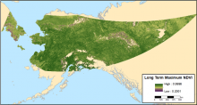
Long-term maximum NDVI for the ABoVE study area covering the years 2002-2017.
Annual maximum NDVI estimates from 2002-2017 are available for most of Alaska and the Yukon Territory.

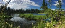
Scientists with the ABoVE campaign study the impacts of warming temperatures on northern lakes, like this one in Fairbanks, Alaska. (Image credit: NASA/Kate Ramsayer)
Field site locations that correspond to the flight tracks of the 2017 ABoVE Airborne Campaign have been published.

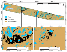
High-resolution elevation maps, based on LiDAR, were used to model the distribution of permafrost across the Y-K Delta of Alaska. The map insets show detail for areas of relative high elevation (left) and low elevation (right).
Scientists with NASA's ABoVE field campaign modeled the distribution of permafrost across the Yukon-Kuskokwim Delta of Alaska.

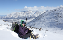
Anne Nolin collects data on snowpack properties as part of a NASA ABoVE study examining how changing snow conditions affect Dall sheep in Wrangell St-Elias National Park, 20 March 2017. (Photo courtesy of Laura Prugh)
Scientists with NASA's ABoVE field campaign are studying links between snowpack properties and Dall sheep populations and movement.

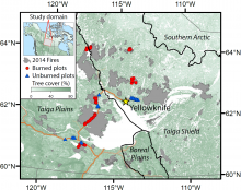
Field measurements were collected in seven spatially independent burn scars, within the Yellowknife megafire complex, which had burned between June and August 2014.
New data from NASA's ABoVE field campaign provide estimates of carbon emissions from the 2014 NWT mega-fire complex.

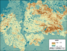
The differenced Normalized Burned Ratio (dNBR) for a burn scar from fires in 2015 within ABoVE grid tile Bh05Bv03. A higher dNBR indicates a higher fire severity.
New data from NASA's ABoVE campaign provides a high-resolution record of differenced Normalized Burned Ratio (dNBR) for fires from 1985-2015.
