Body
Automated digital cameras provide a record of snow conditions in Alaska's Dall sheep habitat.

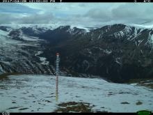
A remote camera image showing the snow stake at Plot 15 of the Jaeger Mesa/Rambler Mine study area.
Automated digital cameras provide a record of snow conditions in Alaska's Dall sheep habitat.

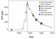
Radiocarbon concentration (delta14C) in the atmosphere over time, showing the bomb peak in 1966 (red dotted line) and theoretical positions of delta14C of soil depth increments (points).
Researchers with NASA's ABoVE field campaign measured soil and forest stand age at burned sites in Canada's Northwest Territories.

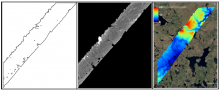
Example of AirSWOT radar products in ABoVE Projection at 3.6 m resolution, for a flight over the ABoVE C grid Ch065v034. Left: Shape for backscatter image. Middle: Backscatter magnitude shows bright reflection in the near range and no returns, yielding regions of no data, in the far range. Right: Derived elevation product.
The ABoVE project has released data from AirSWOT flights in Summer 2017 collected over Alaska and Canada.

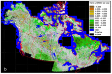
NDVI trends derived from 30 m Landsat NDVI times series for 1984-2012 across Canada and Alaska.
A new dataset from NASA's ABoVE campaign provides trends in NDVI over the Landsat era.

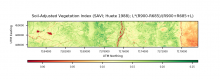
Soil Adjusted Vegetation Index (SAVI) for a site on the Seward Peninsula, Alaska collected on August 14, 2018. SAVI is similar to NDVI, but it suppresses the effects of soil pixels and it uses a canopy background adjustment factor. The reflectance data used to calculate SAVI was collected by the AVIRIS-NG instrument on a flight over the Seward Peninsula, Alaska, on August 14, 2018.
New AVIRIS-NG data from the 2018 ABoVE airborne campaign and an accompanying data processing tutorial are now available.

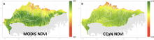
MODIS (left) and CCaN (right) average growing season NDVI.
A new study of long-term NDVI trends across the North Slope of Alaska presents high-resolution growing-season NDVI from MODIS.

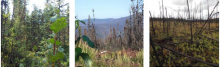
Photos from July 2017 field surveys near Tanana, Alaska, from left to right: unburned forest site; burned forest near the Spicer Creek Fire; high burn severity forest site.
Researchers with NASA's ABoVE field campaign measured burn severity in spruce forests that burned in 2015 near Tanana, Alaska.

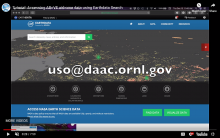
A screenshot of the tutorial video, 'Accessing ABoVE airborne data using Earthdata Search.'
A new tutorial, available on our Resources page, demonstrates how to get ABoVE airborne data sampled at a specific field site.

Forced diffusion chambers were established at the seven sites along a south-to-north transect from near Fairbanks to Toolik Lake, Alaska.
Soil surface CO2 efflux in Alaska is available from the ABoVE field campaign.

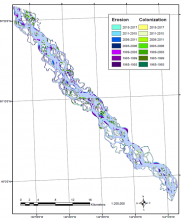
Riverbank erosion and vegetation colonization at the Yukon River 1 study area, located along the Middle Yukon River between Circle and Fort Yukon, Alaska, from 1985-2017.
Research from NASA's ABoVE campaign provides a record of riverbank erosion and vegetation colonization along major Alaskan rivers from 1984 to 2017.
