Body
Researchers with NASA's Carbon Monitoring System estimated the amount of carbon stored in the soil in tidal wetlands of the United States.

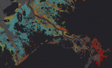
Estimated soil carbon stocks (using model results) throughout the Mississippi River delta in Louisiana. Cooler colors (blues and greens) indicate higher soil carbon concentrations.
Researchers with NASA's Carbon Monitoring System estimated the amount of carbon stored in the soil in tidal wetlands of the United States.

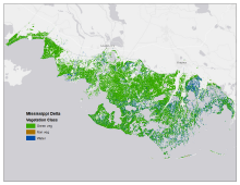
Map of tidal marsh green vegetation, non-vegetation, and open water at 1m resolution for the Mississippi River Delta site in Terrebonne and St. Mary Parishes, Louisiana.
Three new datasets from NASA's Carbon Monitoring System provide high-resolution maps of six US tidal marshes.

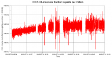
Column-average CO2 measured during the first 20 minutes of flight off the coast of New Jersey on July 11, 2016, for the ACT-America mission.
A new dataset provides remotely-sensed column-average carbon dioxide concentrations measured over the Eastern US.

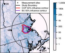
Measurement stations in the Boston area including two urban sites: Boston University (BU) and Copley Square (COP), and three boundary sites: Harvard Forest (HF), Canaan (CA), and Martha's Vineyard (MVY). Blue shading represents 2014 average afternoon CO2 emissions. See the dataset user guide for more details.
A new dataset from the North American Carbon Program provides atmospheric measurements of CO2 and model estimates of urban emissions at sites near Boston, Massachusetts, USA.

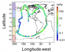
Flight tracks of the NASA DC-8 during the ATom-1 deployment. The scale to the right represents black carbon mass-mixing ratio in units of ng rBC/kg of air.
New data collected during ATom flights provide measurements of aerosols and black carbon concentrations in the atmosphere.

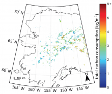
Total pyrogenic carbon consumption estimated from the AKFED between 2001 and 2012 (from Fig. 5 in Veraverbeke et al. 2015).
AKFED provides estimates of annual carbon emissions (kg carbon per square meter) from boreal fires in Alaska between 2001 and 2013.
