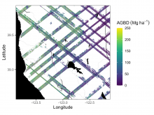
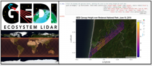
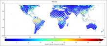
DAAC Home > Resources > News

News

GEDI

First GEDI Level 4 Biomass Data Highlighted by NASA's Earthdata

Submitted by ORNL DAAC Staff on 2021-08-26
Image Media
Image Media
Caption

Example subset of aboveground biomass density (AGBD; Mg ha-1) predictions from the GEDI Level-4A footprint version 2.1 product over Northern California, USA, spanning April to July 2019. GEDI footprints are spaced 60m along track and 600m across-track.

Body
GEDI L4A Footprint Level Aboveground Biomass Density, Version 1 released.

GEDI Level 3 Data Highlighted by NASA's Earthdata

Submitted by ORNL DAAC Staff on 2021-04-11
Image Media
Image Media
Caption

The GEDI instrument onboard the ISS uses three lasers split into eight tracks that fire 242 times per second illuminating a 25-meter footprint of the Earth's surface.

Body
GEDI Level 3 gridded estimates of canopy height, ground elevation, and laser footprint counts from the instrument's full waveform lidar from the International Space Station. Image Credit: NASA's GSFC.

GEDI Launched!

Submitted by ORNL DAAC Staff on 2018-11-29
Image Media
Image Media
Caption

The GEDI instrument's 80 cm telescope will receive laser-light returning from Earth.

Body

The Global Ecosystem Dynamics Investigation (GEDI) instrument will produce the first high-resolution laser ranging observations of the 3D structure of the Earth.