In-situ Water Surface Elevation, MRD, Louisiana, USA, 2021
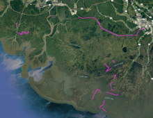
Map of boat survey areas during the Fall 2021 Delta-X campaign.
Herbaceous aboveground biomass (megagrams/hectare) product for the Atchafalaya and Terrebonne Basins, coastal Louisiana, derived from AVIRIS-NG data collected during the April and August 2021.
Location of sites in Alaska, U.S., and Alberta, Canada (left, red triangles) and calibration plot (right) for the Campbell Scientific CS625 soil moisture sensor and five types of organic soils.
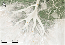
Suspended and bed sediment sampling locations in the Wax Lake Delta, Louisiana. Clusters of measurements are grouped together into single points on this map. Map excludes measurements made far upstream of the Wax Lake Delta or in the Terrebonne River Basin.
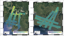
AirSWOT L2 geocoded UTM height maps collected on April 1, 2021 over the Atchafalaya Basin (left), and April 5, 2021 over the Western Terrebonne basin (right).
AirSWOT L3 water surface elevations collected on April 1, 2021 over the Atchafalaya Basin. Each point is colored based on its elevation with respect to the NAVD88 vertical datum (GEOID12B), as shown in the colorbar.
The 2007 Anaktuvuk River fire burned across riparian stringers and wet channels around high-centered polygons that are typically left as unburned inclusions. (2008 photo by D. Yokel). Source: Jandt et al., 2012.
Delta-X is a 5-year NASA Earth Venture Suborbital-3 mission to study the subsidence and growth of the Mississippi River Delta in the United States.
Four subregions of Alaska (left) with example of lakes and ponds derived from PlanetScope imagery (right). Lake and pond extents include monthly climatological composites (May - September) and 3-year composites for 2019-2021. The inset for the Fairbanks (FB) region shows a close-up of the water extents overlain on sub-meter Esri base map imagery. The Yukon Flats (YF) inset shows variability in surface area of large lakes. The Delta Junction (DJ) inset shows seasonal changes in the area of small ponds. The Yukon-Kuskokwim Delta (YKD) inset shows the spatial variability of water body areas in this region and is an example of a 3-year composite.
Multi-year mean (2016-2018) of percent tree cover maps for Mexico.