Body
Merged data from ATom's first two flight campaigns (August 2016 and February 2017) were updated with revised data along with edits to the author list and user guide.

The Atmospheric Tomography (ATom) Mission is an Earth Venture Suborbital-2 mission to measure greenhouse gases and human-produced air pollution in remote areas.
Merged data from ATom's first two flight campaigns (August 2016 and February 2017) were updated with revised data along with edits to the author list and user guide.

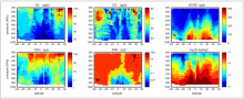
Latitude by pressure plots of six key species from the simulated ATom data stream used in the Prather et al. 2018 study.
A new dataset from the Atmospheric Tomography Mission (ATom) provides a simulated data stream for comparison with six global atmospheric chemistry models.

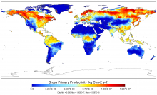
Global monthly 0.5-degree Gross Primary Productivity (GPP) in July 2010 from model LPJ-wsl's SG3 simulation.
Version 1 of the Multi-scale Synthesis and Terrestrial Model Intercomparison Project (MsTMIP) model outputs are now available.

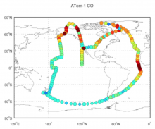
Carbon monoxide concentrations from QCLS instrument during the ATom-1 flight circuit in 2016.
A new dataset provides a direct comparison of observational and simulated CO that will be used to inform atmospheric modeling experiments.

The ORNL DAAC provides user-friendly access to VIIRS and MODIS data through a suite of online tools and APIs.
Join us on August 16 to learn how to discover, subset, access and visualize MODIS and VIIRS data products using a suite of user-friendly tools.

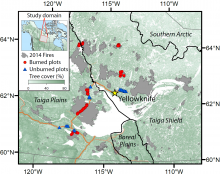
Field measurements were collected in seven spatially independent burn scars, within the Yellowknife megafire complex, which had burned between June and August 2014.
New data from NASA's ABoVE field campaign provide estimates of carbon emissions from the 2014 NWT mega-fire complex.


The ACT-America team on the tarmac with the NASA Langley Beechcraft B-200 King Air and NASA GSFC C-130-H Hercules aircraft in Shreveport, LA.
Data from the Winter 2017 campaign has been added to all ACT-America datasets.

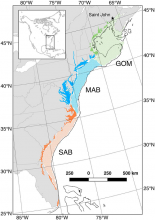
Study domain indicating locations of estuaries and shelf waters in the three subregions: the Gulf of Maine (GOM), the Mid-Atlantic Bight (MAB), and the South Atlantic Bight (SAB; From Najjar et al. 2018).
New data from the North American Carbon Program (NACP) provide mean annual carbon fluxes in coastal areas of Eastern North America.

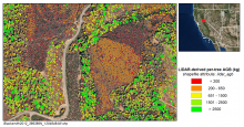
Per-tree aboveground biomass (kg) derived from LiDAR-measured tree heights for the Blacksmith site in 2012.
A new dataset provides LiDAR-derived estimates of aboveground biomass from locations throughout California between 2005 and 2014.
 per-tree derived from LiDAR at the Blacksmith site in 2012")
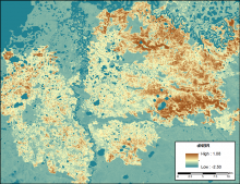
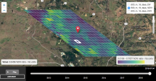
The differenced Normalized Burned Ratio (dNBR) for a burn scar from fires in 2015 within ABoVE grid tile Bh05Bv03. A higher dNBR indicates a higher fire severity.
New data from NASA's ABoVE campaign provides a high-resolution record of differenced Normalized Burned Ratio (dNBR) for fires from 1985-2015.
