Body
Tree data, canopy cover, and vertical profile metrics from forests in Gabon have been published.


Researchers collecting field data in Mondah Forest, Gabon, for the AfriSAR project. Photo credit: Carla Thomas, NASA, 2016
Tree data, canopy cover, and vertical profile metrics from forests in Gabon have been published.

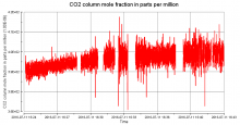
Column-average CO2 measured during the first 20 minutes of flight off the coast of New Jersey on July 11, 2016, for the ACT-America mission.
A new dataset provides remotely-sensed column-average carbon dioxide concentrations measured over the Eastern US.

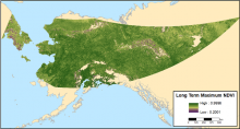
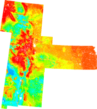
Long-term maximum NDVI for the ABoVE study area covering the years 2002-2017.
Annual maximum NDVI estimates from 2002-2017 are available for most of Alaska and the Yukon Territory.

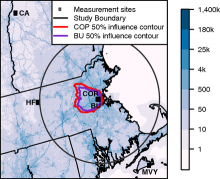
Measurement stations in the Boston area including two urban sites: Boston University (BU) and Copley Square (COP), and three boundary sites: Harvard Forest (HF), Canaan (CA), and Martha's Vineyard (MVY). Blue shading represents 2014 average afternoon CO2 emissions. See the dataset user guide for more details.
A new dataset from the North American Carbon Program provides atmospheric measurements of CO2 and model estimates of urban emissions at sites near Boston, Massachusetts, USA.

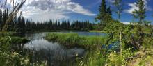
Scientists with the ABoVE campaign study the impacts of warming temperatures on northern lakes, like this one in Fairbanks, Alaska. (Image credit: NASA/Kate Ramsayer)
Field site locations that correspond to the flight tracks of the 2017 ABoVE Airborne Campaign have been published.

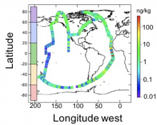
Flight tracks of the NASA DC-8 during the ATom-1 deployment. The scale to the right represents black carbon mass-mixing ratio in units of ng rBC/kg of air.
New data collected during ATom flights provide measurements of aerosols and black carbon concentrations in the atmosphere.

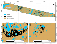
High-resolution elevation maps, based on LiDAR, were used to model the distribution of permafrost across the Y-K Delta of Alaska. The map insets show detail for areas of relative high elevation (left) and low elevation (right).
Scientists with NASA's ABoVE field campaign modeled the distribution of permafrost across the Yukon-Kuskokwim Delta of Alaska.

Visualization of surface soil organic carbon fractions across the Great Plains region, USA, using nearest neighbor interpolation (from the ORNL DAAC Spatial Data Access Tool).
A new dataset provides gridded estimates of organic carbon in soil at 1 km resolution across four US states.

A site within the National Ecological Observatory Network demonstrates that Daymet data can now be accessed using the Fixed Sites Subsets Tool.
For study sites in North America, Daymet daily weather data is now provided alongside pre-processed MODIS and VIIRS data subsets.

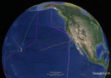
Flight lines of the NASA Atmospheric Tomography Mission (ATom) viewed in Google Earth.
Explore detailed flight track and aircraft navigation data from all four campaigns of the NASA Atmospheric Tomography Mission (ATom).
