Body
New maps show the degree of deforestation in tropical America, Africa, and Asia between 2000 and 2012 and provide estimates of aboveground live biomass loss.

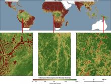
Aboveground live biomass in the year 2000 (from Zarin et al., 2016).
New maps show the degree of deforestation in tropical America, Africa, and Asia between 2000 and 2012 and provide estimates of aboveground live biomass loss.
.")
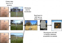
The wireless architecture of the SoilSCAPE network.
The SoilSCAPE network collected 20-minute soil moisture and temperature data at over 200 locations from 2011 to 2016.

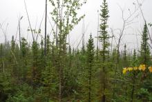
The Arctic-Boreal Vulnerability Experiment (ABoVE) is a NASA Terrestrial Ecology Program.
ORNL DAAC is hosting a webinar specifically for ABoVE researchers.
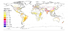
Total livestock methane emissions in 2011, downscaled to 0.05 x 0.05 degree resolution, for the globe (figure from Wolf et al. 2017).
Researchers with NASA's Carbon Monitoring System calculated the annual carbon fluxes associated with global livestock feed and emissions.

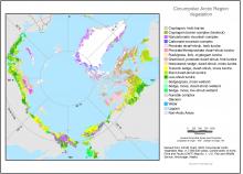
Distribution of vegetation types across the entire circumpolar Arctic region.
An international effort to map the vegetation and associated characteristics throughout the circumpolar region are provided in a new data set.

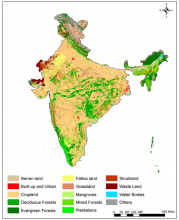
Land use and land cover map of India for 2005.
Satellite imagery was used to generate new high-resolution land use & land cover maps for India for 1985, 1995, and 2005.

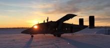
The CARVE C-23 Sherpa prepares to take off from Fairbanks, AK.
The CARVE campaign sampled greenhouse gases in the Arctic using aircraft and ground-based sensors.

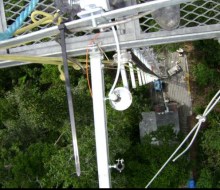
View from the top of tower TT34 looking down on sampling line.
A new data set provides measurements from the Amazonian Aerosol Characterization Experiment.

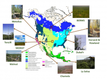
AirMOSS flights during 2012-2015 provided repeated measurements of soil moisture in nine different North American biomes.
L1 Sigma-0 data from >900 data takes of the AirMOSS radar is now available.

The Fish Creek unburned site, Plot 1
Soil characteristics, carbon storage and soil depth measurements from black spruce forests that have burned twice in the past ~50 years are presented in a new data set.
