Body
MODIS satellite data inform study of human land use patterns and changes in ecological communities in tropical forests around the world.


MODIS satellite data inform study of human land use patterns and changes in ecological communities in tropical forests around the world.
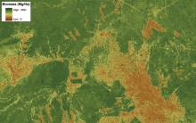
A time series of high-resolution land cover classifications from 1975 – 2000 for the Amazon Basin of Brazil is now available from the ORNL DAAC. Rates of deforestation can be calculated by comparing the extent of primary forest between dates.
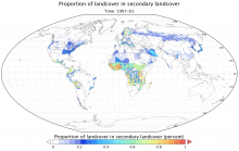
A comprehensive, harmonized data set describing the annual land use patterns of the globe from the year 1500 to the present, and projections to the year 2100, is now available from the ORNL DAAC.

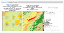
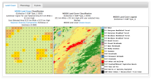
The powerful MODIS subsetting tool allows users to access 14 different products from NASA's Terra and Aqua satellites for any site in the world from the year 2000 to the present.
High-resolution LiDAR-derived maps of aboveground biomass at four forested sites in the US are now available from the ORNL DAAC.

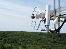
Data from AmeriFlux towers helps refine models of carbon exchange between land and air.
A data set describing the land use history of the globe for the past 500 years, and the next 100 years, is now available from the ORNL DAAC.
A regridded, user-friendly, version of the Harmonized World Soil Database has been published by the ORNL DAAC.
Web Services for the Daymet Single Pixel Extraction Routine are now available through the Daymet website.
The ORNL DAAC is pleased to announce the release of LBA-ECO CD-08 Leaf Carbon, Nitrogen, LAI, and Isotope Data, Manaus, Brazil: 2001. This data set was prepared by S.