Body
Daymet Version 4's improved algorithm and sensor timing and bias corrections result in more accurate and precise data.

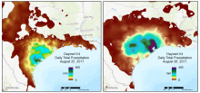
A regional view of Daymet V4 daily total precipitation over 2 days during the time period that Hurricane Harvey made landfall in August of 2017.

Dr. Peter Thornton studies the interactions of land ecosystems with other components of the Earth's climate system including biogeochemical and physical land-atmosphere feedbacks, and interactions with human systems.
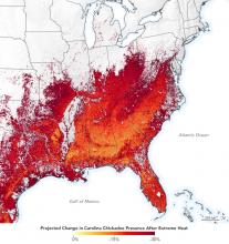
After a week of extreme heat, the Carolina Chickadee was less present, compared to normal weather conditions. Image credit: NASA's Earth Observatory
Daymet data were used to investigate how bird species respond to extreme weather conditions throughout eastern North America.
Dr. Sparkle Malone uses NASA data including the ORNL DAAC Global Subsets Tool and Daymet data for her research on carbon fluxes in the Everglades.
Dr. Sparkle Malone, uses NASA data to explore how a changing climate impacts ecosystem structure and function.
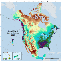
Annual Total of Daily Precipitation, 2019, shown in Daymet V4 gridded estimates.
Improvements in daymet continental-scale gridded daily precipitation and temperature estimates.
Unidata's THREDDS Data Server (TDS) is a web server that provides metadata and data access for scientific datasets, using a variety of remote data access protocols.
A bug has been fixed in the THREDDS Data Server (TDS) NetCDF Subsetting Service (NCSS) that may, in rare cases, have returned incorrect results.
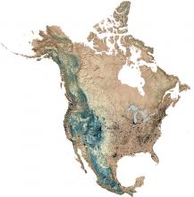
Each black dot on this digital elevation map (DEM) represents a surface weather station in continental North America providing Daymet data in 2010. Additional stations providing Daymet data are located in Puerto Rico and Hawaii.
Daymet derived annual average of daily minimum temperature, 1980 (left) and 2019 (right), for a subset of North America. Images are scaled from -20 to +20 degrees C.

The Single Pixel Extraction Tool allows a user to obtain daily Daymet data in a tabular format for a single geographic point (pixel) specified by latitude and longitude.
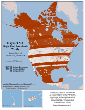
Daymet gridded estimates of daily weather parameters are now available for the years 1980 to 2019.
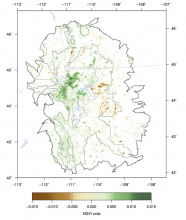
Trends in maximum annual NDVI for natural vegetation within the Greater Yellowstone Ecosystem (GYE) from 1989 to 2014 (Emmett et al. 2019).
Daymet and North American Carbon Program (NACP) data were used to study Normalized Difference Vegetation Index (NDVI) trends across the Greater Yellowstone Ecosystem.


Yaxing Wei has been named Lead Scientist of the ORNL DAAC.
Geospatial information scientist, Dr. Yaxing Wei, is the new ORNL DAAC Lead Scientist.
