Body
This dataset provides the annual date of snowpack seasonal beginning melt across northwest Canada; Alaska, U.S.; and parts of far eastern Russia for 1988-2016.

Spatial extent of snowpack main melt onset dataset (MMOD) extending from the Russian Far East across Alaska into Canada's Northwest Territories and British Columbia. Source: Pan et al. (2021)
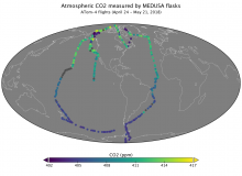
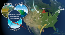
Collection locations of atmospheric carbon dioxide concentration from flasks collected by the Medusa system during ATom-4 flights in 2018.
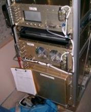
The AO2 instrument used to collect airborne Oxygen and Carbon Dioxide measurements on HIPPO flights from 2009 through 2011.
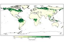
Area fraction of each grid cell of primary lands covered by forests in the year 2000.
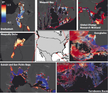
Relative tidal elevation (Z*) representing diverse locations spanning the Conterminous United States.
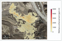
The AVIRIS-NG instrument detected large methane plumes coming from Sunshine Canyon Landfill during its October 2016 overpass. The plumes are shown in a yellow to red gradient, with red representing higher concentrations of methane. Image credit: Cusworth et al. 2020.
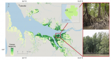
Globally the tallest mangrove forests in coastal Gabon are estimated up to 63 m. The photo insets show locations where individual trees were measured in situ up to 65 m tall (Simard et al., 2019).
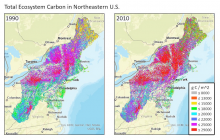
Estimated total ecosystem carbon for the northeast region of the U.S. for the years 1990 (left) and 2010 (right). The estimates were produced from an inventory-constrained version of the Carnegie-Ames-Stanford Approach (CASA) carbon cycle process model.

Optics of Photosynthesis Laboratory Logo