Body
A new dataset maps the aboveground biomass of Maryland's forests and estimates their potential for future carbon sequestration.

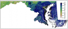
Carbon sequestration potential within the state of Maryland, defined as 95% of maximum forest aboveground biomass (Mg/ha), simulated after 500 years of succession.
A new dataset maps the aboveground biomass of Maryland's forests and estimates their potential for future carbon sequestration.

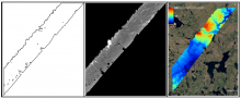
Example of AirSWOT radar products in ABoVE Projection at 3.6 m resolution, for a flight over the ABoVE C grid Ch065v034. Left: Shape for backscatter image. Middle: Backscatter magnitude shows bright reflection in the near range and no returns, yielding regions of no data, in the far range. Right: Derived elevation product.
The ABoVE project has released data from AirSWOT flights in Summer 2017 collected over Alaska and Canada.

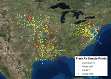
Locations of ACT-America flask air samples from all flight data available to date.
Atmospheric trace gas concentrations collected by the ACT-America project have been updated to include Fall 2017 and Spring 2018 flights.

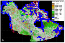
NDVI trends derived from 30 m Landsat NDVI times series for 1984-2012 across Canada and Alaska.
A new dataset from NASA's ABoVE campaign provides trends in NDVI over the Landsat era.

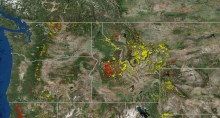
The webinar featured data on the locations of forest disturbance by fire (red) and insect infestation (yellow) across northwestern USA between 2006 and 2010.
The recording of our NASA Earthdata webinar on "Introduction to Geospatial Analysis in R" is now available.

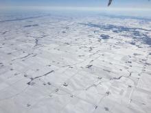
Photograph of the Midwestern United States taken during a Fall 2017 ACT-America flight. A storm system had recently brought a blanket of snow to the region. (Image credit: NASA/Bing Lin)
Atmospheric gas data from all four seasonal flight campaigns (Summer 2016, Winter 2017, Fall 2017, and Spring 2018) are now available from the ACT-America mission.

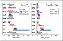
Seasonal quartiles of total CO2 concentrations and fossil fuel CO2 concentrations for each of the nine observation sites in California, 2014-2015.
A new dataset provides estimates of CO2 emissions from fossil fuels across California in 2014-2015.

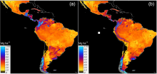
Country-specific (a) and regional (b) predictions of SOC across Latin America based on a linear ensemble of methods.
A new dataset offers baseline estimates of soil organic carbon for Latin American countries.

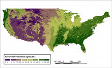
Spatial distribution of 64 ecosystem functional type (EFT) categories across the conterminous United States (CONUS). For each pixel, the dominant EFT is reported.
New data from the Carbon Monitoring System classifies ecosystems based on their similar ecosystem functioning.

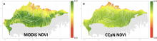
MODIS (left) and CCaN (right) average growing season NDVI.
A new study of long-term NDVI trends across the North Slope of Alaska presents high-resolution growing-season NDVI from MODIS.
