Body
The AfriSAR campaign produced maps of aboveground biomass for four forested sites in Gabon based on field data and LiDAR scans.

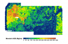
Aboveground biomass mapped at 0.25 ha resolution for the Mondah study site in Gabon, West Africa.
The AfriSAR campaign produced maps of aboveground biomass for four forested sites in Gabon based on field data and LiDAR scans.

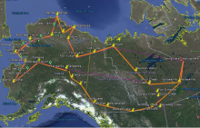
Arctic-CAP flight lines (orange) sampled Arctic and boreal regions of Alaska and Canada. Pins mark the locations of vertical profiles that were repeatedly acquired during the 2017 growing season.
Atmospheric carbon and methane concentrations were measured during the 2017 Arctic Carbon Aircraft Profile (Arctic-CAP) flights throughout Alaska and western Canada.


The Land Processes DAAC distributes NASA Earth Observing System data. They developed the AppEEARS tool to provide access to a wide range of data from instruments including MODIS, VIIRS, SMAP, and now Daymet.
Daymet Version 3 daily weather data for North America is now available through the AppEEARS subsetting tool from NASA's Land Processes DAAC.

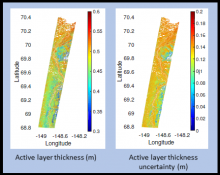
Active layer thickness with uncertainty for a flight swath over the northern section of Alaska's Dalton Highway in summer 2015.
NASA's ABoVE airborne campaign provides estimates of active layer thickness and soil properties derived from the AirMOSS instrument.

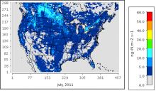
Soil nitrous oxide emissions on a monthly average basis for July 2011 estimated with the mechanistic scheme.
A new model dataset improves the timing and spatial distribution of estimates of soil nitrogen emissions.

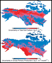
Uncertainty in soil carbon stocks and gross primary productivity across the ABoVE domain.
Work from NASA's ABoVE compared model outputs to estimate the uncertainty in six components of the carbon cycle across Alaska and Canada.

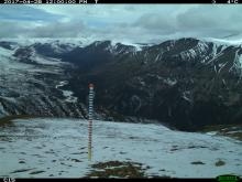
A remote camera image showing the snow stake at Plot 15 of the Jaeger Mesa/Rambler Mine study area.
Automated digital cameras provide a record of snow conditions in Alaska's Dall sheep habitat.

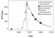
Radiocarbon concentration (delta14C) in the atmosphere over time, showing the bomb peak in 1966 (red dotted line) and theoretical positions of delta14C of soil depth increments (points).
Researchers with NASA's ABoVE field campaign measured soil and forest stand age at burned sites in Canada's Northwest Territories.

Periodic fires near Paradise, California (in 2001, 2008, and 2018) observed from MODIS as recorded in the newly released MCD64A1 product: MODIS/Terra and Aqua Burned Area Monthly L3.
Several updates are now available for MODIS Land Products, including the addition of the Collection 6 phenology product.

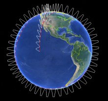
Generalized overview of ATom flights. During each of the four campaigns, ATom flights originated from California, flew south over the Pacific Ocean, then north to the western Arctic, southwest to New Zealand, east to Chile and the Atlantic Ocean, north to Greenland, and returned to California across North America. During flights, the aircraft continuously profiled the atmosphere from 0.2 to 12 km altitude.
The Atmospheric Tomography Mission (ATom) has released multi-instrument merged data from all four flight campaigns spanning from 2016 - 2018.
