Body
Global Ecosystem Dynamics Investigation (GEDI) L4A Footprint Level Aboveground Biomass Density Version 2.1 now available.

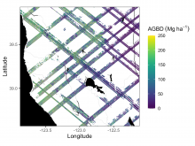
Example subset of aboveground biomass density (AGBD; Mg ha-1) predictions from the GEDI Level-4A footprint version 2.1 product over Northern California, USA, spanning April to July 2019. GEDI footprints are spaced 60m along track and 600m across-track.
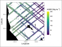
Example subset of aboveground biomass density (AGBD; Mg ha-1) predictions from the GEDI Level-4A footprint product over Northern California, U.S., spanning April to July 2019. GEDI footprints are spaced 60m along-track and 600m across-track.
Logo of the Global Ecosystem Dynamics Investigation (GEDI) mission.
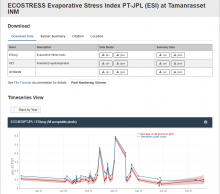
Fixed Site Subset screen shot for the Tumanrasset INM site in Algeria of the AERONET and BSRN networks.
Example subset of aboveground biomass density (AGBD; Mg ha-1) predictions from the GEDI Level-4A footprint product over Northern California, U.S., spanning April to July 2019. GEDI footprints are spaced 60m along-track and 600m across-track.
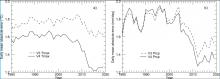
Annual timeseries of daily cross-validation mean absolute error (MAE), averaged over all station days for each year, comparing results for Daymet V4 and Daymet V3. (a) MAE for estimation of daily maximum temperature. (b) MAE for estimation of daily total precipitation. Image from Thornton et al. 2021.
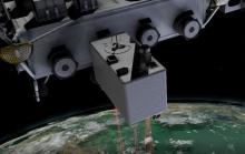
The Global Ecosystem Dynamics Investigation (GEDI) instrument provides high resolution laser ranging of Earth's forests and topography from the International Space Station (ISS).

Representational State Transfer (REST) services for Global Subsets Tool now replace Simple Object Access Protocol (SOAP) services.
Example subset of aboveground biomass density (AGBD; Mg ha-1) predictions from the GEDI Level-4A footprint version 2.1 product over Northern California, USA, spanning April to July 2019. GEDI footprints are spaced 60m along track and 600m across-track.
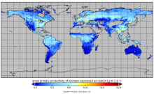
Gross primary production from FluxSat v2.0 expressed as carbon (g m-2 d-1) for July 1st, 2019.