Body
GEDI Level 3 gridded estimates of canopy height, ground elevation, and laser footprint counts from the instrument's full waveform lidar from the International Space Station. Image Credit: NASA's GSFC.


The GEDI instrument onboard the ISS uses three lasers split into eight tracks that fire 242 times per second illuminating a 25-meter footprint of the Earth's surface.
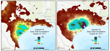
A regional view of Daymet V4 daily total precipitation over 2 days during the time period that Hurricane Harvey made landfall in August of 2017.
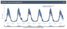
Level 4 SMAP Net Ecosystem Exchange (SPL4CMDL) Global daily 9km Gross Primary Productivity (GPP) mean subset for the Colorado Slate River Crested Butte site as graphed from the Fixed Sites Subsets Tool.
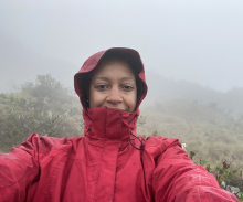
Dr. Sparkle Malone uses NASA data including the ORNL DAAC Global Subsets Tool and Daymet data for her research on carbon fluxes in the Everglades.
Dr. Sparkle Malone, uses NASA data to explore how a changing climate impacts ecosystem structure and function.
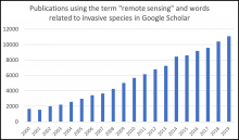
Searching for the term remote sensing and words related to invasive species (invasive, nonnative, exotic, or nonindigenous) in Google Scholar reveals an increasing number of publications each year using these terms.
A new Earthdata article describes how researchers are using remote sensing to map invasive species.
Responsive design with multiple products and site ordering features now available in Global Subsets Tool for MODIS/VIIRS Land Products.
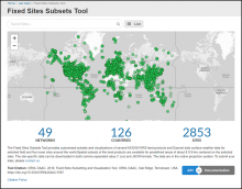
The Fixed Sites Subsets Tool provides customized, pre-processed, subsets and visualizations of land products for selected field and flux tower sites around the world.
Pre-processed subsets of VIIRS LST and SMAP NEE products are now available for many long-term research sites.

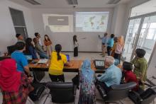
Dr. Don McNeil and his students analyzing data in the classroom. The projected wall image on the left shows the result of a MODIS data subset using the ORNL DAAC's Global Subsets Tool. The projected wall image on the right shows thematic maps of daily land surface temperature increase in North and South America and Antarctica using a laterally rotated Mollweide Earth projection. Image courtesy of Dr. McNeil.
Dr. Don McNeil and students at Prince of Songkla University in Thailand use NASA Earth observing data to study environmental change.

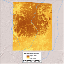
Average daily net radiation for the 8-day timestep, 2000-03-29 to 2000-04-06, in the upper Xingu River Basin, Mato Grosso, Brazil, study area.
Three MODIS products were used to derive daily average land surface net radiation for the forests of the upper Xingu River Basin in Mato Grosso, Brazil.

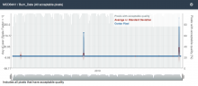
Periodic fires near Paradise, California (in 2001, 2008, and 2018) observed from MODIS as recorded in the newly released MCD64A1 product: MODIS/Terra and Aqua Burned Area Monthly L3.
Several updates are now available for MODIS Land Products, including the addition of the Collection 6 phenology product.
