Body
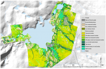
ABoVE researchers compiled a map of ecosystem states prior to the 2014 & 2015 fires in the Northwest Territories, Canada.

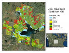
Ecosystem map for the Great Slave Lake area, Northwest Territories, Canada, for the period 1997-2011.
ABoVE researchers compiled a map of ecosystem states prior to the 2014 & 2015 fires in the Northwest Territories, Canada.

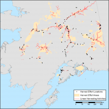
Combined map of subsistence resource use areas of Interior Alaskan communities with (1) points marking harvest effort locations, (2) polygons indicating harvest effort areas, and (3) lines indicating linear harvesting activity.
Maps of the search and harvest areas used by residents of Interior Alaska are available.

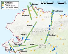
AirMOSS radar swaths flown in 2014 and 2015 in Alaska. In situ soil moisture and temperature profile measurements were obtained at the CALM (Circumpolar Active Layer Monitoring) and the UAF GIPL (Geophysical Institute Permafrost Laboratory, University of Alaska Fairbanks) sites and used to validate AirMOSS data products.
Airborne Microwave Observatory of Subcanopy and Subsurface (AirMOSS) radar data from Alaska are used to derive estimates of active layer thickness. Data from flights in 2014 and 2015 are now available.

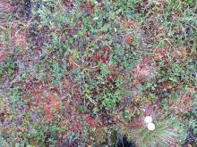
A plot photo (#0656) taken at the largest study area 'Toolik' at elevation 765.7 m. The small white object was included in many of the photos as a color reference. The photographer's boots are also often visible, in this photo they are to the lower left of the white object.
A new ABoVE dataset offers hundreds of ground-based vegetation photos which may serve as a reference for studies of climate and vegetation change in the area.

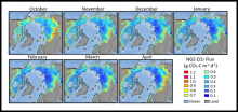
Mean daily soil CO2 flux in each month of the non-growing season (NGS) during the baseline period (2003-2018). Gridded estimates are provided at 25-km resolution for the pan-Arctic and Boreal permafrost region.
New data from the Arctic-Boreal Vulnerability Experiment (ABoVE) provide winter soil CO2 flux estimates for the pan-Arctic and Boreal regions.

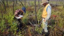
Investigators collected field data and inventoried plots for vegetation species and growth in 2018 at a post-burn site. (Image Credit: Laura Bourgeau-Chavez)
A new dataset completes four years of post-fire vegetation sampling at burned sites in Canada's Northwest Territories.

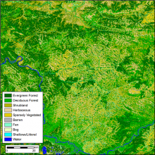
Land cover (10-class product) for the year 2014 for ABoVE tile BH03V04. The pixel resolution is 30 m and a tile is 180 x 180 km.
Research from NASA's ABoVE project provides annual land cover classifications from 1984 to 2014 for Alaska and the Canadian Arctic.

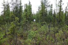
Active layer thaw depth was recorded each year during the late summer from 2014 - 2018 at sites including the Farmer's Loop Transect 2 near Fairbanks. (Image Credit: Tom Douglas)
Two new datasets provide soil active layer thaw depth and end-of-season snow depth at sites near Fairbanks, Alaska.

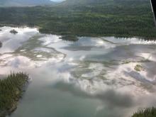
This photo from June 2016 shows the 'extreme' growth of lake grass in a lake near the Tok Community, Alaska.
ABoVE researchers worked with rural communities to document environmental changes that affect access to subsistence resources.

Vegetation communities for the Toolik footprint shown at 1:25,000 scale.
Plant communities near Toolik Lake research station in Alaska were classified at 20 cm resolution based on airborne imagery and lidar surveys.
